IMAGES TAKEN NEAR TO
Kingston Avenue, MACCLESFIELD, SK11 7DL
Introduction
This page details the photographs taken nearby to Kingston Avenue, SK11 7DL by members of the Geograph project.
The Geograph project started in 2005 with the aim of publishing, organising and preserving representative images for every square kilometre of Great Britain, Ireland and the Isle of Man.

There are currently over 7.5m images from over14,400 individuals and you can help contribute to the project by visiting https://www.geograph.org.uk
Image Map
Images are licensed for reuse under creativecommons.org/licenses/by-sa/2.0
Notes
- Clicking on the map will re-center to the selected point.
- The higher the marker number, the further away the image location is from the centre of the postcode.
Image Listing (24 Images Found)
Images are licensed for reuse under creativecommons.org/licenses/by-sa/2.0
Image
Details
Distance
1
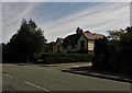
Monsall Drive off Buxton Road, Macclesfield
Image: © Neil Theasby
Taken: 16 Aug 2016
0.10 miles
2
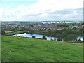
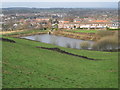
Reservoir in Macclesfield
In the background are the Hovis Mill on the left, and the white sprawl of Astra-zeneca.
Image: © Neil Lewin
Taken: 27 Aug 2006
0.14 miles
3
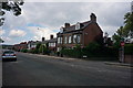
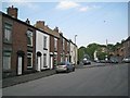
Buxton Road, Macclesfield
Opposite the junction with Cottage Lane.
Image: © Peter Barr
Taken: 30 Jun 2014
0.14 miles
4
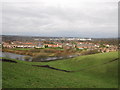
Another view from Blakelow Road, Macclesfield
Looking slightly more northerly than my other view over the fields below Blakelow Road, the white scar of the Hurdsfield Industrial Estate can be seen.
Image: © Peter Turner
Taken: 14 Dec 2011
0.16 miles
5
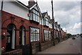
Red brick terrace villas
On Buxton Road, Macclesfield.
Image: © Peter Barr
Taken: 30 Jun 2014
0.19 miles
6

'A very open prospect to the rear'
That description could be applied to any of the properties whose rears are shown here. The dark trees on the right are the grounds of Eddisbury Hall. The house roofs visible at the left edge are down on Buxton Road.
Image: © Peter Turner
Taken: 14 Dec 2011
0.20 miles
7
A view from Blakelow Road, Macclesfield
Looking down over the fields from Blakelow Road over Leadbeater's Reservoir with the Hovis Mill and chimney in the middle ground and diagonally left behind the mill St Michael's Church in the town centre.
Image: © Peter Turner
Taken: 14 Dec 2011
0.20 miles
8
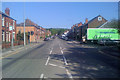
Buxton Road A537 climbs out of Macclesfield
The Co-operative delivery lorry conceals the convenience store on the corner of busy Black Road and Buxton Road.
Image: © Robin Stott
Taken: 27 Apr 2011
0.21 miles
9
Blakelow Road, Macclesfield
Looking uphill from the junction with Hollins Road, right, (formerly Pott Lane) and the top of Windmill Street.
Image: © Robin Stott
Taken: 28 Apr 2011
0.21 miles
10
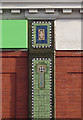
Co-operative store, Buxton Road, mosaic detail
The Black Road frontage has mosaic decoration on the columns. What was this building before?
Image: © Robin Stott
Taken: 12 Nov 2011
0.22 miles