IMAGES TAKEN NEAR TO
Thornycroft Street, MACCLESFIELD, SK11 7AN
Introduction
This page details the photographs taken nearby to Thornycroft Street, SK11 7AN by members of the Geograph project.
The Geograph project started in 2005 with the aim of publishing, organising and preserving representative images for every square kilometre of Great Britain, Ireland and the Isle of Man.

There are currently over 7.5m images from over14,400 individuals and you can help contribute to the project by visiting https://www.geograph.org.uk
Image Map
Images are licensed for reuse under creativecommons.org/licenses/by-sa/2.0
Notes
- Clicking on the map will re-center to the selected point.
- The higher the marker number, the further away the image location is from the centre of the postcode.
Image Listing (156 Images Found)
Images are licensed for reuse under creativecommons.org/licenses/by-sa/2.0
Image
Details
Distance
1
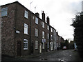
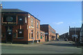
Daintry Terrace, Macclesfield
A short terrace of former silk-weavers' cottages.
Image: © Robin Stott
Taken: 4 Dec 2009
0.03 miles
2
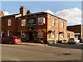
The Wharf
The Wharf public house at the corner of Brook Street and Goodall Street in Macclesfield.
Image: © David Dixon
Taken: 3 Oct 2012
0.05 miles
3
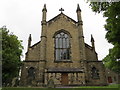
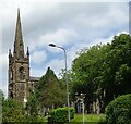
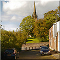
The east end of St Paul's church, Macclesfield
A view of the east end of St Paul's church from the lower level of Daintry Street.
Image: © John S Turner
Taken: 20 Jun 2013
0.05 miles
4
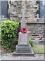
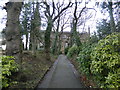
St Paul's war memorial 1914-1919
This memorial to the men of St Paul's who died in the 'Great War' is at the south side of the church at the top of the main churchyard path.
Image: © John S Turner
Taken: 20 Jun 2013
0.06 miles
5
Looking along Goodall Street, Macclesfield
The Wharf public house, on the corner with Brook Street, is closed. Slightly odd appearance is because the corner is greater than a right angle.
Image: © Robin Stott
Taken: 27 Apr 2011
0.06 miles
10
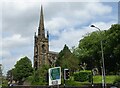
The Parish Church of St Paul, Macclesfield
St Paul's Church, viewed from Cawley Street.
St Paul's Parish Church, Macclesfield, is a Grade II listed building. (http://list.english-heritage.org.uk/resultsingle.aspx?uid=1218224 National Heritage List for England). It was built in 1843–44, an example of a "Commissioners' Church" (http://en.wikipedia.org/wiki/Commissioners%27_church ), having received a grant towards its construction from the Church Building Commission.
Image: © David Dixon
Taken: 3 Oct 2012
0.07 miles