IMAGES TAKEN NEAR TO
Brook Street, MACCLESFIELD, SK11 7AA
Introduction
This page details the photographs taken nearby to Brook Street, SK11 7AA by members of the Geograph project.
The Geograph project started in 2005 with the aim of publishing, organising and preserving representative images for every square kilometre of Great Britain, Ireland and the Isle of Man.

There are currently over 7.5m images from over14,400 individuals and you can help contribute to the project by visiting https://www.geograph.org.uk
Image Map
Images are licensed for reuse under creativecommons.org/licenses/by-sa/2.0
Notes
- Clicking on the map will re-center to the selected point.
- The higher the marker number, the further away the image location is from the centre of the postcode.
Image Listing (160 Images Found)
Images are licensed for reuse under creativecommons.org/licenses/by-sa/2.0
Image
Details
Distance
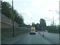
1
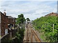
Railway into Macclesfield Railway Station
Looking north on the Stafford to Manchester Line.
Image: © JThomas
Taken: 5 Jul 2024
0.02 miles
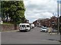
2
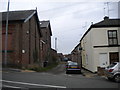
Allen Street, Macclesfield
Off Brook Street, sandwiched between railway (left) and canal a little way east of the town centre.
Image: © Richard Vince
Taken: 12 Oct 2013
0.02 miles
3
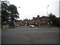
Brook Street crossroads, Macclesfield
At this point, Brook Street crosses The Silk Road as the former climbs east out of the town centre. The Silk Road, part of the A523, forms an inner bypass for Macclesfield, and is named in honour of the industry with which the town was once synonymous.
Image: © Richard Vince
Taken: 12 Oct 2013
0.04 miles
4
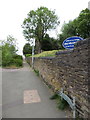
St Paul's churchyard wall in Green Street, Macclesfield
Looking along St Paul's west-facing churchyard wall from the junction of Green Street with Brook Street. Green Street is now closed off at this point as the busy A525 'The Silk Road' takes precedence. The church tower and spire are in the background.
Image: © John S Turner
Taken: 20 Jun 2013
0.05 miles
6
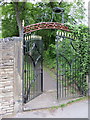
St Paul's churchyard gate, Macclesfield
The main gateway to St Paul's churchyard from Brook Street.
Image: © John S Turner
Taken: 20 Jun 2013
0.05 miles
7
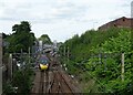
Avanti West Coast train entering Macclesfield Railway Station
Looking north on the Stafford to Manchester Line.
Image: © JThomas
Taken: 5 Jul 2024
0.05 miles
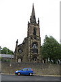
8
The Parish Church of St Paul, Macclesfield
St Paul's Church, viewed from Cawley Street.
St Paul's Parish Church, Macclesfield, is a Grade II listed building. (http://list.english-heritage.org.uk/resultsingle.aspx?uid=1218224 National Heritage List for England). It was built in 1843–44, an example of a "Commissioners' Church" (http://en.wikipedia.org/wiki/Commissioners%27_church ), having received a grant towards its construction from the Church Building Commission.
Image: © David Dixon
Taken: 3 Oct 2012
0.05 miles
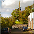
10
St Paul's tower and Spire, Macclesfield
Looking across Green Street towards the west end of St Paul's with its tower and spire.
Image: © John S Turner
Taken: 20 Jun 2013
0.06 miles