IMAGES TAKEN NEAR TO
Statham Street, MACCLESFIELD, SK11 6XL

Introduction

This page details the photographs taken nearby to Statham Street, SK11 6XL by members of the Geograph project.

The Geograph project started in 2005 with the aim of publishing, organising and preserving representative images for every square kilometre of Great Britain, Ireland and the Isle of Man.

There are currently over 7.5m images from over14,400 individuals and you can help contribute to the project by visiting https://www.geograph.org.uk

Image Map


Images are licensed for reuse under creativecommons.org/licenses/by-sa/2.0
Notes
  • Clicking on the map will re-center to the selected point.
  • The higher the marker number, the further away the image location is from the centre of the postcode.

Image Listing (51 Images Found)

Images are licensed for reuse under creativecommons.org/licenses/by-sa/2.0
  • ...
Image
Details
Distance
1
Retail warehouses, Statham Street, Macclesfield
Image: © Robin Stott Taken: 4 Dec 2009
0.03 miles
2
Macclesfield - Paradise St
A well preserved line of silk weaving houses. Large windows in the top floor were originally silk weaving workshops.
Image: © Colin Park Taken: 25 Mar 2018
0.08 miles
3
Punctilious punctuation (on St. John's School date stone)
Date stone for St. John's School, Hatton Street (see photo Image). Today we are rather careless about punctuation, but this example from 1869 goes to the other extreme. The most common function of a full stop is to indicate the end of a sentence; 'St. John's School' and the date '1869' are not sentences, so really do not need them. Full marks for effort though!
Image: © Antony Dixon Taken: 1 Nov 2011
0.09 miles
4
Former St. John's School and Methodist Chapel
This is the corner of Hatton Street and South Park Road. The impressive Methodist Chapel has now been converted into flats and the school appears to be in business use. For a close-up of the school's date stone, see Image
Image: © Antony Dixon Taken: 1 Nov 2011
0.09 miles
5
Northern Chamber Orchestra concert, Heritage Centre Macclesfield
The Heritage Centre started life as the Roe Street Sunday School built by private subscription and opened in 1814. Nowadays the large hall is used for concerts and as a cinema for public performances and for a film club. Other parts of the building house part of the Macclesfield Silk museum and a cafe/restaurant.
Image: © Peter Turner Taken: 14 Jan 2012
0.15 miles
6
Macclesfield - West Bond Street
Image: © Colin Park Taken: 3 Jan 2010
0.17 miles
7
Macclesfield - View N along Bond St
Image: © Colin Park Taken: 25 Mar 2018
0.17 miles
8
Silk bobbins in Paradise Mill, Macclesfield
Paradise Mill is attached to Macclesfield's Silk Museum. Finally closed in 1981, it still contains many of the original looms and associated machinery associated with silk production.
Image: © Neil Theasby Taken: 16 Aug 2016
0.18 miles
9
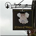
Sign of the Prince of Wales
Sign for the Prince of Wales Image
Image: © Gerald England Taken: 27 Sep 2016
0.18 miles
10
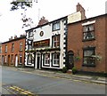
Porter's Prince of Wales
In 2007 the Prince of Wales pub (also known as Porters) on Roe Street was under threat of demolition as part of proposals for a walkway in the area http://www.manchestereveningnews.co.uk/news/greater-manchester-news/pub-saviour-loses-her-home-981231 A campaign to save it won the day although the changed plans meant four other Georgian houses in the street were demolished instead. Although the pub sign reads "Prince of Wales" Image the name-board on the front just reads "Ale House".
Image: © Gerald England Taken: 27 Sep 2016
0.18 miles
  • ...