IMAGES TAKEN NEAR TO
Sunderland Street, MACCLESFIELD, SK11 6LF
Introduction
This page details the photographs taken nearby to Sunderland Street, SK11 6LF by members of the Geograph project.
The Geograph project started in 2005 with the aim of publishing, organising and preserving representative images for every square kilometre of Great Britain, Ireland and the Isle of Man.

There are currently over 7.5m images from over14,400 individuals and you can help contribute to the project by visiting https://www.geograph.org.uk
Image Map
Images are licensed for reuse under creativecommons.org/licenses/by-sa/2.0
Notes
- Clicking on the map will re-center to the selected point.
- The higher the marker number, the further away the image location is from the centre of the postcode.
Image Listing (280 Images Found)
Images are licensed for reuse under creativecommons.org/licenses/by-sa/2.0
Image
Details
Distance
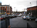
2
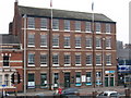
Waters Green House & The Wyldes, Park Rd, Macclesfield
Image: © N Chadwick
Taken: 22 Mar 2009
0.02 miles
3
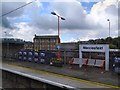
Macclesfield - Park Street
West side of Park Street, near railway station.
Image: © Dave Bevis
Taken: 21 Mar 2009
0.03 miles
5
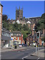
Macclesfield - Water's Green & St Michael's Church
Image: © Colin Park
Taken: 6 Sep 2015
0.03 miles
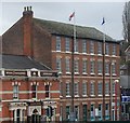
6
Macclesfield - Waters Green House
Photo taken from the pedestrian ramp to the railway station entrance.
Image: © Dave Bevis
Taken: 21 Mar 2009
0.04 miles
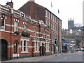
9
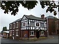
Waters Green Tavern
Town centre pub near the railway station
Image: © Graham Hogg
Taken: 1 Oct 2012
0.04 miles
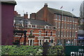
10
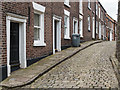
Churchside, Macclesfield
Nice row of Georgian terraced houses and setts at Macclesfield.
Image: © Martin Froggatt
Taken: 4 Aug 2019
0.04 miles