IMAGES TAKEN NEAR TO
Step Hill, MACCLESFIELD, SK11 6JU
Introduction
This page details the photographs taken nearby to Step Hill, SK11 6JU by members of the Geograph project.
The Geograph project started in 2005 with the aim of publishing, organising and preserving representative images for every square kilometre of Great Britain, Ireland and the Isle of Man.

There are currently over 7.5m images from over14,400 individuals and you can help contribute to the project by visiting https://www.geograph.org.uk
Image Map
Images are licensed for reuse under creativecommons.org/licenses/by-sa/2.0
Notes
- Clicking on the map will re-center to the selected point.
- The higher the marker number, the further away the image location is from the centre of the postcode.
Image Listing (234 Images Found)
Images are licensed for reuse under creativecommons.org/licenses/by-sa/2.0
Image
Details
Distance
1
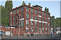
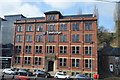
Silk warehouse
This fine building was the last silk warehouse, but is now occupied by a firm of printers.
The building faces onto Gas Road; this rather mundane name is due to the fact that Macclesfield was one of the first local authorities to build its own gasworks.
Image: © Alan Murray-Rust
Taken: 16 Sep 2007
0.01 miles
2
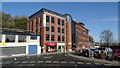
Macclesfield Central Travelodge
Travelodge Macclesfield Central, Castle House, Gas Road.
Image: © David Dixon
Taken: 15 May 2012
0.01 miles
3
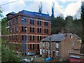
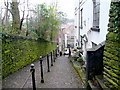
Step Hill, Macclesfield
One of three stepped ways linking the upper town around the church with the lower part in the Bollin valley. Created from sandstone setts which are a feature of many older streets in the town.
Image: © Alan Murray-Rust
Taken: 25 Jan 2018
0.02 miles
7
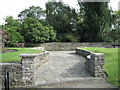
Entrance to the Brocklehurst Memorial Gardens
Behind the Town Hall and overlooking the east side of Macclesfield where trees permit; aka Sparrow Park. In the parapet wall, left of centre, is a commemorative stone Image
Image: © Robin Stott
Taken: 25 Sep 2010
0.03 miles
8
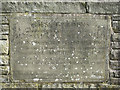
Commemorative stone, Brocklehurst Memorial Gardens.
The gardens, more a public walk, run along the edge of the cliff to the east of the town centre.
The inscription reads:
THESE GARDENS
made on land given by
AUGUSTUS HEWETSON ESQ
&
FRANCIS D BROCKLEHURST ESQ
owe their inception to the appeal launched by
Councillor Mrs A M WHITE (Mayor 1951-2)
and to the generosity of the People of
Macclesfield for whose delight they are intended
"I will lift up mine eyes unto the hills"
Image: © Robin Stott
Taken: 25 Sep 2010
0.03 miles
9
Brunswick Hill, Macclesfield 2
Looking east, away from the town centre.
Image: © Jonathan Billinger
Taken: 17 Feb 2009
0.04 miles
10
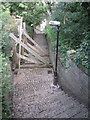
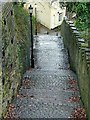
Step Hill, Macclesfield
AKA Public footpath No 53, between Churchside at the top and Waters Green at the bottom. It is temporarily closed while repairs to a retaining wall are carried out.
Image: © Robin Stott
Taken: 25 Sep 2010
0.04 miles