IMAGES TAKEN NEAR TO
Charlotte Street West, MACCLESFIELD, SK11 6EF
Introduction
This page details the photographs taken nearby to Charlotte Street West, SK11 6EF by members of the Geograph project.
The Geograph project started in 2005 with the aim of publishing, organising and preserving representative images for every square kilometre of Great Britain, Ireland and the Isle of Man.

There are currently over 7.5m images from over14,400 individuals and you can help contribute to the project by visiting https://www.geograph.org.uk
Image Map
Images are licensed for reuse under creativecommons.org/licenses/by-sa/2.0
Notes
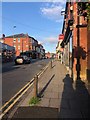
- Clicking on the map will re-center to the selected point.
- The higher the marker number, the further away the image location is from the centre of the postcode.
Image Listing (171 Images Found)
Images are licensed for reuse under creativecommons.org/licenses/by-sa/2.0
Image
Details
Distance
1
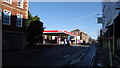
Macclesfield - Petrol Station on Churchill Way
Image: © Colin Park
Taken: 25 Mar 2018
0.02 miles
2
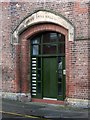
Drill Hall, Bridge Street
The main entrance, dated 1872. The inscription refers to the 8th Cheshire Rifle Volunteers. See http://www.geograph.org.uk/photo/5667401 for location.
Image: © Alan Murray-Rust
Taken: 25 Jan 2018
0.05 miles
3
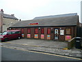
Built like a brick toilet
Public toilets on Churchill Way.
Image: © michael ely
Taken: 13 May 2010
0.05 miles
4
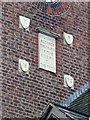
Dedicatory plaque, Drill Hall, Bridge Street
On the north face of the tower. See http://www.geograph.org.uk/photo/5667401 for location.
Image: © Alan Murray-Rust
Taken: 25 Jan 2018
0.05 miles
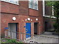
5
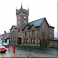
Drill Hall, Bridge Street
The administrative buildings, with tower, built in 1872, now converted to apartments. The actual hall, to the rear, no longer exists.
Image: © Alan Murray-Rust
Taken: 25 Jan 2018
0.05 miles
6
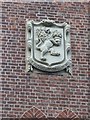
Drill Hall, Bridge Street - detail
Plaque with shield and motto. See http://www.geograph.org.uk/photo/5667401 for location.
Image: © Alan Murray-Rust
Taken: 25 Jan 2018
0.05 miles
7
Khandro Ling Buddhist Centre, Macclesfield
Situated on Pierce Street.
Image: © Jonathan Billinger
Taken: 17 Feb 2009
0.06 miles
8
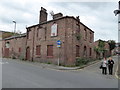
Old pub in Macclesfield
No longer trading, as with all too many pubs over the last decade or so.
Image: © Jeremy Bolwell
Taken: 24 Sep 2016
0.06 miles
9
Chestergate, Macclesfield
Taken from the end of the queue for "The Picturedrome" on the last night of the "Eat Out to Help Out" initiative
Image: © Philip Cornwall
Taken: 26 Aug 2020
0.07 miles
10
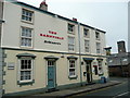
The Barnfield, Catherine Street, Macclesfield
For another back-street Robinson's house in town - see Image
Image: © Jonathan Billinger
Taken: 17 Feb 2009
0.07 miles