IMAGES TAKEN NEAR TO
Rushton Spencer, MACCLESFIELD, SK11 0SG
Introduction
This page details the photographs taken nearby to SK11 0SG by members of the Geograph project.
The Geograph project started in 2005 with the aim of publishing, organising and preserving representative images for every square kilometre of Great Britain, Ireland and the Isle of Man.

There are currently over 7.5m images from over14,400 individuals and you can help contribute to the project by visiting https://www.geograph.org.uk
Image Map
Images are licensed for reuse under creativecommons.org/licenses/by-sa/2.0
Notes
- Clicking on the map will re-center to the selected point.
- The higher the marker number, the further away the image location is from the centre of the postcode.
Image Listing (26 Images Found)
Images are licensed for reuse under creativecommons.org/licenses/by-sa/2.0
Image
Details
Distance
1
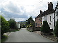
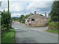
Sugar Street, Rushton Spencer
A part of the village away from the main road.
Image: © David Weston
Taken: 30 Aug 2014
0.02 miles

4
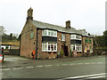
The Royal Oak at Rushton Spencer
A good country pub.
Image: © Stephen Craven
Taken: 28 Dec 2018
0.07 miles
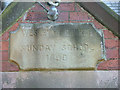
5

The Royal Oak, Rushton Spencer
Six years previously - Image]
Image: © JThomas
Taken: 5 Jul 2024
0.07 miles
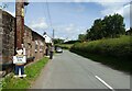
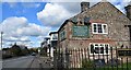
7
The Royal Oak, Rushton Spencer
The pub is on the corner of Sugar Street, which leads to the right. The minor road in the foreground meets the A523, going towards Macclesfield.
Image: © David Weston
Taken: 30 Aug 2014
0.07 miles
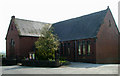
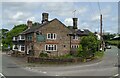
10
The Royal Oak in Rushden spencer.
A community owned pub.
Image: © steven ruffles
Taken: 7 Mar 2023
0.08 miles