IMAGES TAKEN NEAR TO
Rushton Spencer, MACCLESFIELD, SK11 0RS
Introduction
This page details the photographs taken nearby to SK11 0RS by members of the Geograph project.
The Geograph project started in 2005 with the aim of publishing, organising and preserving representative images for every square kilometre of Great Britain, Ireland and the Isle of Man.

There are currently over 7.5m images from over14,400 individuals and you can help contribute to the project by visiting https://www.geograph.org.uk
Image Map
Images are licensed for reuse under creativecommons.org/licenses/by-sa/2.0
Notes
- Clicking on the map will re-center to the selected point.
- The higher the marker number, the further away the image location is from the centre of the postcode.
Image Listing (3 Images Found)
Images are licensed for reuse under creativecommons.org/licenses/by-sa/2.0
Image
Details
Distance
2

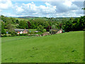
Towards High Lee
This is the very narrow lane looking towards High Lee from Nether Lee. Just around the bend is, of course, where I met the tractor coming the other way.
Image: © Neil Lewin
Taken: 19 May 2007
0.16 miles