IMAGES TAKEN NEAR TO
Wincle, MACCLESFIELD, SK11 0QQ
Introduction
This page details the photographs taken nearby to SK11 0QQ by members of the Geograph project.
The Geograph project started in 2005 with the aim of publishing, organising and preserving representative images for every square kilometre of Great Britain, Ireland and the Isle of Man.

There are currently over 7.5m images from over14,400 individuals and you can help contribute to the project by visiting https://www.geograph.org.uk
Image Map
Images are licensed for reuse under creativecommons.org/licenses/by-sa/2.0
Notes
- Clicking on the map will re-center to the selected point.
- The higher the marker number, the further away the image location is from the centre of the postcode.
Image Listing (22 Images Found)
Images are licensed for reuse under creativecommons.org/licenses/by-sa/2.0
Image
Details
Distance
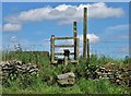
1
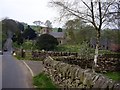
Lane Head Farm
with the farmer's daughter?
Image: © Neil Lewin
Taken: 10 Jun 2007
0.00 miles
3
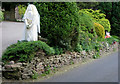
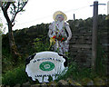
Left at the Altar
Could that be the bridegroom hiding in the bushes?
Image: © Neil Lewin
Taken: 10 Jun 2007
0.17 miles
4
Churchbank Cottage
What a fantastic cross 'growing' out of the lawn.
Image: © Neil Lewin
Taken: 10 Jun 2007
0.18 miles
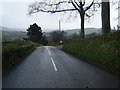
6
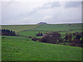
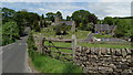
Wincle - view from Barlow Hill towards Shutlingsloe
Wincle: SJ 9552 6662 @ 035° - view from near the top of Barlow Hill towards Shutlingsloe; Wild Boar PH on the A54 just visible in middle distance.
Image: © Mike Harris
Taken: 16 Nov 2006
0.20 miles
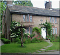
7
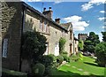
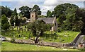
Cottages and St Michael's Church, Wincle
Image: © Neil Theasby
Taken: 12 Jul 2020
0.20 miles