IMAGES TAKEN NEAR TO
Hollin Lane, MACCLESFIELD, SK11 0NL
Introduction
This page details the photographs taken nearby to Hollin Lane, SK11 0NL by members of the Geograph project.
The Geograph project started in 2005 with the aim of publishing, organising and preserving representative images for every square kilometre of Great Britain, Ireland and the Isle of Man.

There are currently over 7.5m images from over14,400 individuals and you can help contribute to the project by visiting https://www.geograph.org.uk
Image Map
Images are licensed for reuse under creativecommons.org/licenses/by-sa/2.0
Notes
- Clicking on the map will re-center to the selected point.
- The higher the marker number, the further away the image location is from the centre of the postcode.
Image Listing (4 Images Found)
Images are licensed for reuse under creativecommons.org/licenses/by-sa/2.0
Image
Details
Distance
1
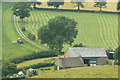
Haymaking at Cophurst
The dry weather has come at the right time for a bumper crop.
Image: © Alan Murray-Rust
Taken: 28 Jun 2010
0.16 miles
3
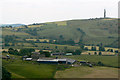
High Lee
Farmstead above Higher Sutton, with Sutton Common transmitter on the skyline.
Image: © Alan Murray-Rust
Taken: 28 Jun 2010
0.21 miles
4
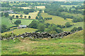
Looking down to Cophurst
View over the head of the "other" Rossendale.
Image: © Alan Murray-Rust
Taken: 28 Jun 2010
0.22 miles