IMAGES TAKEN NEAR TO
Sutton, MACCLESFIELD, SK11 0NJ
Introduction
This page details the photographs taken nearby to SK11 0NJ by members of the Geograph project.
The Geograph project started in 2005 with the aim of publishing, organising and preserving representative images for every square kilometre of Great Britain, Ireland and the Isle of Man.

There are currently over 7.5m images from over14,400 individuals and you can help contribute to the project by visiting https://www.geograph.org.uk
Image Map
Images are licensed for reuse under creativecommons.org/licenses/by-sa/2.0
Notes
- Clicking on the map will re-center to the selected point.
- The higher the marker number, the further away the image location is from the centre of the postcode.
Image Listing (13 Images Found)
Images are licensed for reuse under creativecommons.org/licenses/by-sa/2.0
Image
Details
Distance
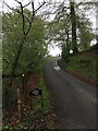
1
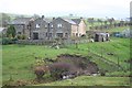
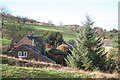
Lower Pethills Farm
Viewed from the bridleway on the other side of Rossen Clough.
Image: © Dave Dunford
Taken: 22 Nov 2014
0.01 miles
2

Lower Pethills Farm, Rossen Clough
The dark part of the skyline is the top of Macclesfield Forest.
Image: © Peter Turner
Taken: 14 Apr 2012
0.01 miles
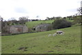
3
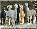
A chorus line
Alpacas at Little Pethills Farm
Image: © Anthony O'Neil
Taken: 28 Oct 2021
0.02 miles
4
Rossen Clough and Lower Pethills
From a rather muddy bridleway between Civit Hills and Lower Pethills Farms.
Image: © Dave Dunford
Taken: 22 Nov 2014
0.04 miles
5
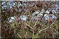
Alder (Alnus glutinosa)
Alder (Alnus glutinosa) cones and catkins on the bridleway between Higher and Lower Pethills Farm.
Image: © Dave Dunford
Taken: 22 Nov 2014
0.11 miles
6
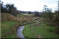
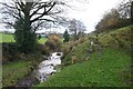
Rossen Clough
Pretty spot, on an indifferent day. Muddy bridleway between Civit Hills and Lower Pethills Farms.
Image: © Dave Dunford
Taken: 22 Nov 2014
0.12 miles
8
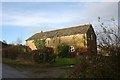
Barn at Higher Pethills Farm
Converted barn, from the public bridleway.
Image: © Dave Dunford
Taken: 22 Nov 2014
0.19 miles
10
Higher Pethills Farm
With Milkingsteads Farm on the skyline behind.
Image: © Dave Dunford
Taken: 22 Nov 2014
0.20 miles