IMAGES TAKEN NEAR TO
Withenshaw Lane, MACCLESFIELD, SK11 0NH
Introduction
This page details the photographs taken nearby to Withenshaw Lane, SK11 0NH by members of the Geograph project.
The Geograph project started in 2005 with the aim of publishing, organising and preserving representative images for every square kilometre of Great Britain, Ireland and the Isle of Man.

There are currently over 7.5m images from over14,400 individuals and you can help contribute to the project by visiting https://www.geograph.org.uk
Image Map
Images are licensed for reuse under creativecommons.org/licenses/by-sa/2.0
Notes
- Clicking on the map will re-center to the selected point.
- The higher the marker number, the further away the image location is from the centre of the postcode.
Image Listing (8 Images Found)
Images are licensed for reuse under creativecommons.org/licenses/by-sa/2.0
Image
Details
Distance
1
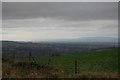
Withenshaw
Looking up at the farm from Hollin Lane.
Image: © Alan Murray-Rust
Taken: 28 Jun 2010
0.04 miles
2
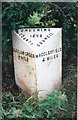
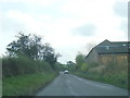
Old Milepost in Hollin Lane, south of Macclesfield
Cast iron post by the UC road, in parish of Sutton (Macclesfield District), South of Hollinset Farm, in hedge, on East side of road. Cast iron CCC1898, erected by the County Council in the 19th century.
Inscription reads:-
: CLEULOW CROSS / ½ MILE : : CHESHIRE / 1898 / COUNTY COUNCIL : : MACCLESFIELD / 4 MILES :
Maker:-
: W H SMITH & CO / MAKERS / WHITCHURCH :
Milestone Society National ID: CH_MFCX04
Image: © J Higgins
Taken: 1 Jul 2003
0.13 miles
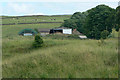
3
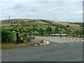
Hayfields near Hollinset Farm
Cut, dried and stored. The fields my provide a second crop or be used instead for grazing.
Image: © Alan Murray-Rust
Taken: 28 Jun 2010
0.17 miles
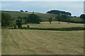
4
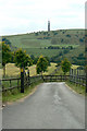
Drive to Hollinset Farm
Sutton Common transmitter on the skyline.
Image: © Alan Murray-Rust
Taken: 28 Jun 2010
0.21 miles
6
Hollinset Farm
with the ever-present Sutton Common transmitter on the horizon
Image: © Neil Lewin
Taken: 29 Jul 2006
0.22 miles
7
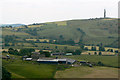
High Lee
Farmstead above Higher Sutton, with Sutton Common transmitter on the skyline.
Image: © Alan Murray-Rust
Taken: 28 Jun 2010
0.23 miles