IMAGES TAKEN NEAR TO
Meg Lane, MACCLESFIELD, SK11 0LY
Introduction
This page details the photographs taken nearby to Meg Lane, SK11 0LY by members of the Geograph project.
The Geograph project started in 2005 with the aim of publishing, organising and preserving representative images for every square kilometre of Great Britain, Ireland and the Isle of Man.

There are currently over 7.5m images from over14,400 individuals and you can help contribute to the project by visiting https://www.geograph.org.uk
Image Map
Images are licensed for reuse under creativecommons.org/licenses/by-sa/2.0
Notes
- Clicking on the map will re-center to the selected point.
- The higher the marker number, the further away the image location is from the centre of the postcode.
Image Listing (23 Images Found)
Images are licensed for reuse under creativecommons.org/licenses/by-sa/2.0
Image
Details
Distance

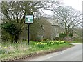
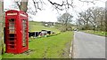
2
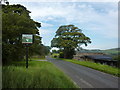
Higher Sutton
Farmhouse, phone box and village sign.
Image: © Peter Barr
Taken: 18 Aug 2011
0.02 miles
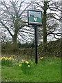
3
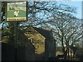
Higher Sutton
This is the 'village' sign for the small hamlet of Higher Sutton which appears to consist of 2 farms and 3-4 houses.
Image: © Roger Temple
Taken: 17 Jan 2007
0.03 miles
4
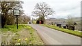
Higher Sutton
A hamlet rather than a village
Image: © Chris Morgan
Taken: 18 Apr 2016
0.03 miles
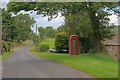
9
Just another sad red box
Once a typical village feature, the telepohone box. At least this one looks well looked after, albeit currently almost empty.
Image: © Chris Morgan
Taken: 18 Apr 2016
0.07 miles