IMAGES TAKEN NEAR TO
Walker Barn, MACCLESFIELD, SK11 0AW
Introduction
This page details the photographs taken nearby to SK11 0AW by members of the Geograph project.
The Geograph project started in 2005 with the aim of publishing, organising and preserving representative images for every square kilometre of Great Britain, Ireland and the Isle of Man.

There are currently over 7.5m images from over14,400 individuals and you can help contribute to the project by visiting https://www.geograph.org.uk
Image Map
Images are licensed for reuse under creativecommons.org/licenses/by-sa/2.0
Notes
- Clicking on the map will re-center to the selected point.
- The higher the marker number, the further away the image location is from the centre of the postcode.
Image Listing (30 Images Found)
Images are licensed for reuse under creativecommons.org/licenses/by-sa/2.0
Image
Details
Distance
1
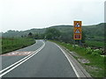
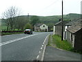
Walker Barn
From the A537 Buxton Road (popular with motorcyclists).
Image: © Dave Dunford
Taken: 14 May 2006
0.03 miles
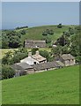
2
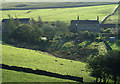
Lower Windyway Farm seen from Buxton Old Road
A windless clear September morning.
The hillside beyond the farm lies inside the Peak District National Park.
Image: © Alan Murray-Rust
Taken: 16 Sep 2007
0.03 miles
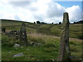
3
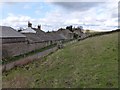
Walker Barn
The ladder stile pictured is short on one side and quite tall on the other - rather awkward if you are short.
Image: © Dave Dunford
Taken: 11 Apr 2015
0.04 miles
4
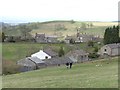
Walker Barn
Descending the pleasant footpath from Macclesfield Forest to the hamlet of Walker Barn.
Image: © Dave Dunford
Taken: 11 Apr 2015
0.04 miles
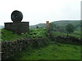
7
Walker Barn, from Gulshaw Hollow
Seen through old stone gateposts, Walker Barn is on the Macclesfield to Buxton road, about 1000 ft above sea level.
Image: © Peter Barr
Taken: 4 Aug 2014
0.05 miles
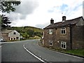
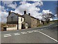
8
Walker Barn
The A537 meets the western boundary of the Peak District. Sadly the inn marked on the 1940s map is no longer in business.
Image: © Dave Dunford
Taken: 14 May 2006
0.05 miles
9
Walker Barn
Small hamlet on a bend of the A537 near Tegg's Nose Country Park. The 1940s map shows an inn here (possibly the building on the right of this picture) but it's now a private dwelling.
Image: © Dave Dunford
Taken: 14 May 2006
0.05 miles
10
Former Setter Dog pub, Walker Barn
Former pub, apparently at one time listed in the Good Pub Guide.
Image: © Dave Dunford
Taken: 11 Apr 2015
0.05 miles