IMAGES TAKEN NEAR TO
Bullhill Lane, MACCLESFIELD, SK11 0AL
Introduction
This page details the photographs taken nearby to Bullhill Lane, SK11 0AL by members of the Geograph project.
The Geograph project started in 2005 with the aim of publishing, organising and preserving representative images for every square kilometre of Great Britain, Ireland and the Isle of Man.

There are currently over 7.5m images from over14,400 individuals and you can help contribute to the project by visiting https://www.geograph.org.uk
Image Map
Images are licensed for reuse under creativecommons.org/licenses/by-sa/2.0
Notes
- Clicking on the map will re-center to the selected point.
- The higher the marker number, the further away the image location is from the centre of the postcode.
Image Listing (16 Images Found)
Images are licensed for reuse under creativecommons.org/licenses/by-sa/2.0
Image
Details
Distance
3
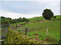
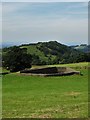
Farmland on the edge of the National Park
View from the lane to Rainow towards Brink Farm. The busy Buxton New Road (A537) is hidden in the dip
Image: © Espresso Addict
Taken: 7 Oct 2006
0.04 miles
4
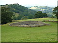
Reservoir, Bull Hill Lane
Small stone enclosed reservoir,with low water level ( perhaps now redundant) in a field, south of Rainow.
Image: © Peter Barr
Taken: 4 Aug 2014
0.05 miles
5
Small reservoir at Higher Bull Hill Farm
Image: © Neil Theasby
Taken: 16 Aug 2016
0.05 miles
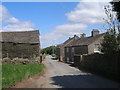
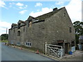
6
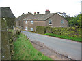
Stone farmhouse on the lane to Rainow
The lane to Rainow forms part of the boundary of the Peak District National Park; this farmhouse near Calrofold is just within the park. The buildings here are typical of many in this part of the Peak District
Image: © Espresso Addict
Taken: 7 Oct 2006
0.09 miles
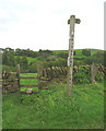
7
Footpath to Rainow
This section of the Gritstone Trail leaves the Image and drops down to Rainow.
Image: © Jonathan Kington
Taken: 23 Mar 2011
0.10 miles
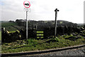
8
Junction of Bull Hill Lane and Buxton New Road
Bull Hill Lane swings to the left going to Macclesfield and to the right for Rainow, Buxton New Road starts on the corner and goes past the camera to Buxton. There is a Fundamental Bench Mark on the verge by the wall on the right (Image).
Image: © Jonathan Kington
Taken: 23 Mar 2011
0.10 miles
9
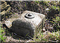
Macclesfield Fundamental Bench Mark
This Fundamental Bench Mark is located by the wall on the eastern side of the Bull Hill Lane and Buxton New Road junction, on the verge by the road. It was used in the Second geodetic levelling (1912-1921) and the Third geodetic levelling (1950-1968) of England and Wales. It was included in both the Macclesfield to Daresbury and the Matlock to Macclesfield levelling lines. Its exact height is 1017.8020 feet (310.2260 metres) above mean sea level at Newlyn. For a wider view see Image, for more information visit http://www.bench-marks.org.uk/bm1110 .
Fundamental Bench Marks are the most important type of mark. Above ground is a small pillar with a brass ‘dome’ on the top, below ground level is a bolt that is set into the bedrock which means there is less chance of it altering. The bolt is an exact height above mean sea level at Newlyn and it is from these Fundamental Bench Marks that all others are measured. Their importance is such that the Ordnance Survey still maintain them.
Image: © Jonathan Kington
Taken: 23 Mar 2011
0.10 miles
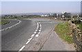
10
Stile on the Gritstone Trail
The Gritstone Trail crosses the Buxton New Road (A537) and turns north east. Hordern Farm in the distance is in Image
Image: © Espresso Addict
Taken: 7 Oct 2006
0.11 miles