IMAGES TAKEN NEAR TO
Shrigley Road, MACCLESFIELD, SK10 5SA
Introduction
This page details the photographs taken nearby to Shrigley Road, SK10 5SA by members of the Geograph project.
The Geograph project started in 2005 with the aim of publishing, organising and preserving representative images for every square kilometre of Great Britain, Ireland and the Isle of Man.

There are currently over 7.5m images from over14,400 individuals and you can help contribute to the project by visiting https://www.geograph.org.uk
Image Map
Images are licensed for reuse under creativecommons.org/licenses/by-sa/2.0
Notes
- Clicking on the map will re-center to the selected point.
- The higher the marker number, the further away the image location is from the centre of the postcode.
Image Listing (27 Images Found)
Images are licensed for reuse under creativecommons.org/licenses/by-sa/2.0
Image
Details
Distance
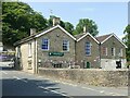
1
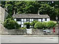
The Croft, Pott Shrigley
Mid 18th century gritstone cottage with imitation black and white timber paint scheme. Listed Grade II.
Image: © Alan Murray-Rust
Taken: 12 Jun 2023
0.00 miles
2
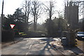
Pott Shrigley
Looking towards the road junction at the centre of the village.
Image: © Trevor Harris
Taken: 19 Feb 2013
0.02 miles
3
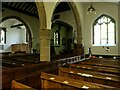
Church of St Christopher, Pott Shrigley
Looking north-east across the nave. The church is almost entirely 15th century, including the nave roof; Listed Grade I.
Image: © Alan Murray-Rust
Taken: 12 Jun 2023
0.02 miles
4
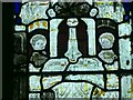
Church of St Christopher, Pott Shrigley
Detail of the east window https://www.geograph.org.uk/photo/7513959 showing two angel musicians in tracery surroundings. The angels are medieval, the remainder of the glass being Victorian. It is clear that at that time replication of medieval stained glass techniques had not been perfected, as in comparison with the angels almost all the fine detail has been lost.
Image: © Alan Murray-Rust
Taken: 12 Jun 2023
0.02 miles
5
Church of St Christopher, Pott Shrigley
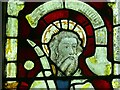
Detail of the east window https://www.geograph.org.uk/photo/7513959 showing the head of St Paul the Apostle. The head itself is medieval, the remainder of the glass being Victorian. It is clear that at that time replication of medieval stained glass techniques had not been perfected, as in comparison with the head almost all the fine detail has been lost.
Image: © Alan Murray-Rust
Taken: 12 Jun 2023
0.02 miles
6
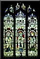
Church of St Christopher, Pott Shrigley
The east window. This was created in the middle of the 19th century and although most of the glass is Victorian, there are small sections of medieval glass https://www.geograph.org.uk/photo/7513958 https://www.geograph.org.uk/photo/7513962 https://www.geograph.org.uk/photo/7513961 .
Image: © Alan Murray-Rust
Taken: 12 Jun 2023
0.02 miles
7
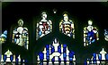
Church of St Christopher, Pott Shrigley
Detail of the east window https://www.geograph.org.uk/photo/7513959 with early 15th century stained glass in the tracery lights. The figures are left, St John the Baptist and right, St Leonard.
Image: © Alan Murray-Rust
Taken: 12 Jun 2023
0.02 miles
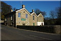
8
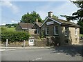
Pott Shrigley School and Village Hall
The right hand section dates from c.1861, the left hand section being added in 1967. Listed Grade II for group value.
Image: © Alan Murray-Rust
Taken: 12 Jun 2023
0.03 miles
9
Pott Shrigley School and Village Hall
The left hand section dates from c.1861, the right hand section being added in 1967. Listed Grade II for group value.
Image: © Alan Murray-Rust
Taken: 12 Jun 2023
0.03 miles
10
Pott Shrigley Village Hall
Pott Shrigley Village Hall is situated opposite the church.
Image: © Philip Halling
Taken: 16 Feb 2008
0.03 miles