IMAGES TAKEN NEAR TO
Nursery Road, MACCLESFIELD, SK10 5DL
Introduction
This page details the photographs taken nearby to Nursery Road, SK10 5DL by members of the Geograph project.
The Geograph project started in 2005 with the aim of publishing, organising and preserving representative images for every square kilometre of Great Britain, Ireland and the Isle of Man.

There are currently over 7.5m images from over14,400 individuals and you can help contribute to the project by visiting https://www.geograph.org.uk
Image Map
Images are licensed for reuse under creativecommons.org/licenses/by-sa/2.0
Notes
- Clicking on the map will re-center to the selected point.
- The higher the marker number, the further away the image location is from the centre of the postcode.
Image Listing (5 Images Found)
Images are licensed for reuse under creativecommons.org/licenses/by-sa/2.0
Image
Details
Distance
2
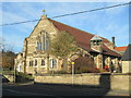
St Oswald's Church, Bollington Cross
The church is Grade II listed, built in 1908.
Image: © David Weston
Taken: 18 Nov 2018
0.13 miles
3
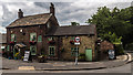
Cock & Pheasant
The Cock & Pheasant public house.
Image: © Peter McDermott
Taken: 11 Jul 2015
0.22 miles
4
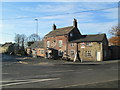
The Cock and Pheasant Inn, Bollington Cross
The building is Grade II listed, dated 1753.
Image: © David Weston
Taken: 18 Nov 2018
0.22 miles
5
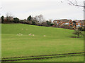
Sheep at Sych House Farm, Bollington
The sheep are in a field to the west of the Middlewood Way on the southern edge of the town. The houses in the photo are a small modern development called Hill View.
Image: © Stephen Craven
Taken: 26 Dec 2011
0.24 miles