IMAGES TAKEN NEAR TO
Whirley Lane, MACCLESFIELD, SK10 4RN
Introduction
This page details the photographs taken nearby to Whirley Lane, SK10 4RN by members of the Geograph project.
The Geograph project started in 2005 with the aim of publishing, organising and preserving representative images for every square kilometre of Great Britain, Ireland and the Isle of Man.

There are currently over 7.5m images from over14,400 individuals and you can help contribute to the project by visiting https://www.geograph.org.uk
Image Map
Images are licensed for reuse under creativecommons.org/licenses/by-sa/2.0
Notes
- Clicking on the map will re-center to the selected point.
- The higher the marker number, the further away the image location is from the centre of the postcode.
Image Listing (3 Images Found)
Images are licensed for reuse under creativecommons.org/licenses/by-sa/2.0
Image
Details
Distance
1

Whirley Hall Henbury Macclesfield
Technically just in Over Alderley CP this authentic late 17th century manor house is a Grade II listed building.
Image: © Peter Turner
Taken: 10 Feb 2012
0.06 miles
2
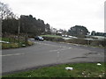
Whirley Lane/Wrigley Lane junction Henbury
Whirley Lane crosses the picture L/R
Image: © Peter Turner
Taken: 10 Feb 2012
0.11 miles
3
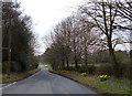
Whirley Lane near Macclesfield
This lane forms part of the Cheshire Cycleway. Looking west from its junction with Andertons Lane.
Image: © michael ely
Taken: 12 Apr 2006
0.23 miles