IMAGES TAKEN NEAR TO
Wilmslow Road, MACCLESFIELD, SK10 4QT
Introduction
This page details the photographs taken nearby to Wilmslow Road, SK10 4QT by members of the Geograph project.
The Geograph project started in 2005 with the aim of publishing, organising and preserving representative images for every square kilometre of Great Britain, Ireland and the Isle of Man.

There are currently over 7.5m images from over14,400 individuals and you can help contribute to the project by visiting https://www.geograph.org.uk
Image Map
Images are licensed for reuse under creativecommons.org/licenses/by-sa/2.0
Notes
- Clicking on the map will re-center to the selected point.
- The higher the marker number, the further away the image location is from the centre of the postcode.
Image Listing (2 Images Found)
Images are licensed for reuse under creativecommons.org/licenses/by-sa/2.0
Image
Details
Distance
1

Footbridge on path connecting Old Wilmslow Road to A538 North of Mottram St. Andrew
A very well-constructed sturdy footbridge crossing a small stream
Image: © Philip Cornwall
Taken: 12 Aug 2021
0.22 miles
2
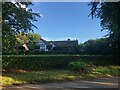
Mottram Old Hall
A Manor House of late Medieval origin. Grade II listed building, see linked entry on the Historic England website https://historicengland.org.uk/listing/the-list/list-entry/1138842
Image: © Philip Cornwall
Taken: 12 Aug 2021
0.23 miles