IMAGES TAKEN NEAR TO
Hunters Pool Lane, MACCLESFIELD, SK10 4QQ
Introduction
This page details the photographs taken nearby to Hunters Pool Lane, SK10 4QQ by members of the Geograph project.
The Geograph project started in 2005 with the aim of publishing, organising and preserving representative images for every square kilometre of Great Britain, Ireland and the Isle of Man.

There are currently over 7.5m images from over14,400 individuals and you can help contribute to the project by visiting https://www.geograph.org.uk
Image Map
Images are licensed for reuse under creativecommons.org/licenses/by-sa/2.0
Notes
- Clicking on the map will re-center to the selected point.
- The higher the marker number, the further away the image location is from the centre of the postcode.
Image Listing (4 Images Found)
Images are licensed for reuse under creativecommons.org/licenses/by-sa/2.0
Image
Details
Distance
1
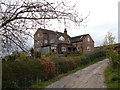
Hunters Pool Farm, Mottram St Andrew
A substantial farmstead at the end of Shaws Lane from where public footpaths lead to the A538, Wilmslow Road.
Image: © michael ely
Taken: 25 Apr 2006
0.04 miles
2
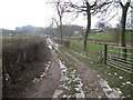
Shaws Lane, Mottram-St-Andrew
North Cheshire Way walkers negotiate these normally soggy stretches but a good frost gives us firm if occasionally slippy footing.
Image: © Peter Turner
Taken: 11 Feb 2012
0.06 miles
3
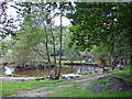
Mottram St. Andrew: Hunter's Pool
Mottram St. Andrew: Hunter's Pool from the North Cheshire Way.
Image: © Mike Harris
Taken: 22 Sep 2006
0.13 miles
4
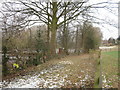
Hunter's Pool, Mottram-St-Andrew
Viewed from the North Cheshire Way the pool is well disguised as a sheet of ice beyond the square brown/white shed.
Image: © Peter Turner
Taken: 11 Feb 2012
0.17 miles