IMAGES TAKEN NEAR TO
Bonis Hall Lane, MACCLESFIELD, SK10 4LR
Introduction
This page details the photographs taken nearby to Bonis Hall Lane, SK10 4LR by members of the Geograph project.
The Geograph project started in 2005 with the aim of publishing, organising and preserving representative images for every square kilometre of Great Britain, Ireland and the Isle of Man.

There are currently over 7.5m images from over14,400 individuals and you can help contribute to the project by visiting https://www.geograph.org.uk
Image Map
Images are licensed for reuse under creativecommons.org/licenses/by-sa/2.0
Notes
- Clicking on the map will re-center to the selected point.
- The higher the marker number, the further away the image location is from the centre of the postcode.
Image Listing (11 Images Found)
Images are licensed for reuse under creativecommons.org/licenses/by-sa/2.0
Image
Details
Distance
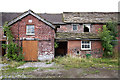
1
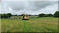
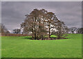
Top o' th' Hill farm
Is becoming a modern mansion with grounds to match
Image: © Chris Morgan
Taken: 5 Jul 2021
0.06 miles
2
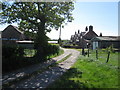
Top o' th' Hill Farm, Prestbury
A reasonably accurate descriptive name but open to discussion in its spelling. The 'H' in hill disappears once dialect is introduced 'Top o' th'ill' might be more dialectically correct or even with 'th' 'ill' as more correct still. Standard English would, however, rob it of its eye-catching quality.
Image: © Peter Turner
Taken: 2 May 2011
0.07 miles
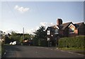
5
An unusual sight!
Derelict property in an area of Cheshire which is more conversant with gentlemen farmers and premier league footballers.
Image: © Anthony O'Neil
Taken: 20 Aug 2014
0.08 miles
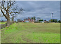
6
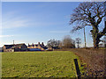
Top o th' Hill
Working farm on the B5358
Image: © Paul Twambley
Taken: 1 Jan 2006
0.13 miles
7
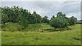
Foxtwist moated site
Full details of this from the Historic England website at; https://historicengland.org.uk/listing/the-list/list-entry/1011864
" Foxtwist moated site survives in good condition and possesses a range of component parts. The site is a rare example in Cheshire of a small homestead moat that is double moated on three sides, and the unusual form exhibited by this site illustrates well the diversity of this class of monument.
The monument at Foxtwist comprises a small homestead moated site, additionally enclosed on three sides by an outer moat, and also adjacent fishponds and connecting channels. The monument includes a raised grass covered island c.31m x 18m possessing faint traces of the foundations of a cottage and the remains of a small orchard. Surrounding the island is an inner moat c.6m wide x 2m deep, waterlogged on the W side where it has formed a pond. Access to the island is from the SW via a well made causeway 3m wide with flanking ditches. A dry outer moat extends around the NW, N and E sides and was fed by a waterlogged pond on higher ground some 90m to the E linked by a channel now much reduced by ploughing. A dry channel, now utilised as a modern field boundary, runs NE-SW adjacent to the E side of the inner moat. Close to the SE corner of the inner moat this channel broadens and deepens and continues S for some 85m before turning W to link with a dry rectangular fishpond c.47m x 12m x 1m deep. William de Foxwist lived in the manor house at the site in the early 13th century. This was dismantled in 1357 and re-erected in Macclesfield where it served as the Market Hall. A new structure was erected on the moated site and this passed by marriage to the Duncalf family, eventually being sold to the Leghs of Adlington in 1609 who have owned the site ever since. By the end of the 17th century a small cottage had been built on the site. This building was demolished c.1920."
Image: © Chris Morgan
Taken: 5 Jul 2021
0.16 miles
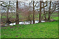
10
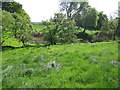
Moat
Antique and very dry. Two ditches exist the inner and deeper is at least 4 or 5 feet deep in parts with a squarish inner raised part which could have had fortification (I assume). I don't know if any archaeology has been practised here but it is an intriguing relic of indeterminate age and purpose.
Image: © Peter Turner
Taken: 2 May 2011
0.18 miles