IMAGES TAKEN NEAR TO
Brookledge Lane, MACCLESFIELD, SK10 4JX
Introduction
This page details the photographs taken nearby to Brookledge Lane, SK10 4JX by members of the Geograph project.
The Geograph project started in 2005 with the aim of publishing, organising and preserving representative images for every square kilometre of Great Britain, Ireland and the Isle of Man.

There are currently over 7.5m images from over14,400 individuals and you can help contribute to the project by visiting https://www.geograph.org.uk
Image Map
Images are licensed for reuse under creativecommons.org/licenses/by-sa/2.0
Notes
- Clicking on the map will re-center to the selected point.
- The higher the marker number, the further away the image location is from the centre of the postcode.
Image Listing (31 Images Found)
Images are licensed for reuse under creativecommons.org/licenses/by-sa/2.0
Image
Details
Distance
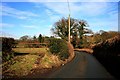
1
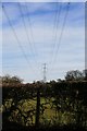
Hedge and power lines
On Roundy Lane, Adlington.
Image: © David Lally
Taken: 11 Feb 2010
0.09 miles
2
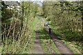
Walkers on the Middlewood Way near Hibbertbrow Farm
Image: © David Martin
Taken: 6 Apr 2024
0.11 miles
3
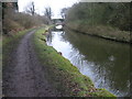
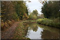
Macclesfield Canal near Brookledge Lane
Image: © Chris Wimbush
Taken: 24 Feb 2009
0.14 miles
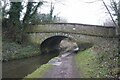
4
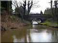
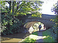
Macclesfield Canal: Hibberts Brow Bridge No 21
Image: © Dr Neil Clifton
Taken: 31 Mar 2015
0.14 miles
6
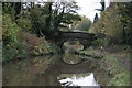
Adlington: Macclesfield Canal at Hibbert's Brow Bridge
Adlington: Macclesfield Canal at Hibbert's Brow Bridge (#21); the North Cheshire Way follows the towpath here.
Image: © Mike Harris
Taken: 23 Sep 2006
0.14 miles
8
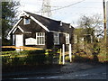
St John's Church
Quaint old "tin shack" of a church in a rather exclusive area of Cheshire
Image: © Paul Twambley
Taken: 1 Jan 2006
0.14 miles