IMAGES TAKEN NEAR TO
Henbury Place, MACCLESFIELD, SK10 4HE
Introduction
This page details the photographs taken nearby to Henbury Place, SK10 4HE by members of the Geograph project.
The Geograph project started in 2005 with the aim of publishing, organising and preserving representative images for every square kilometre of Great Britain, Ireland and the Isle of Man.

There are currently over 7.5m images from over14,400 individuals and you can help contribute to the project by visiting https://www.geograph.org.uk
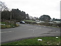
Image Map
Images are licensed for reuse under creativecommons.org/licenses/by-sa/2.0
Notes
- Clicking on the map will re-center to the selected point.
- The higher the marker number, the further away the image location is from the centre of the postcode.
Image Listing (12 Images Found)
Images are licensed for reuse under creativecommons.org/licenses/by-sa/2.0
Image
Details
Distance
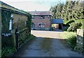

3
Around Henbury (15)
Mossway Farm track
Image: © Anthony O'Neil
Taken: 27 Feb 2022
0.12 miles
5
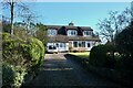
Around Henbury (18)
West View, Andertons Lane
Image: © Anthony O'Neil
Taken: 27 Feb 2022
0.18 miles
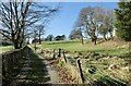
6
Whirley Lane/Wrigley Lane junction Henbury
Whirley Lane crosses the picture L/R
Image: © Peter Turner
Taken: 10 Feb 2012
0.20 miles
7
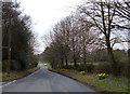
Whirley Lane near Macclesfield
This lane forms part of the Cheshire Cycleway. Looking west from its junction with Andertons Lane.
Image: © michael ely
Taken: 12 Apr 2006
0.20 miles
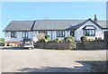
8
Around Henbury (20)
Glencree, Andertons Lane
Image: © Anthony O'Neil
Taken: 27 Feb 2022
0.23 miles
9
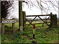
Outskirts of Henbury
View over the fields from the junction of Church Lane, Dark Lane and Andertons Lane.
Image: © michael ely
Taken: 12 Apr 2006
0.24 miles
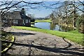
10

Whirley watertower
The watertower perched above Whirleybarn and Whirley Lane, with its obligatory daffodil plantings. I think it is the only watertower and 'header tank' or supply reservoir this side of Macclesfield and probably supplies mainly the rural areas to the west.
Image: © Peter Turner
Taken: 26 Mar 2011
0.24 miles