IMAGES TAKEN NEAR TO
Ashtree Close, MACCLESFIELD, SK10 4EB
Introduction
This page details the photographs taken nearby to Ashtree Close, SK10 4EB by members of the Geograph project.
The Geograph project started in 2005 with the aim of publishing, organising and preserving representative images for every square kilometre of Great Britain, Ireland and the Isle of Man.

There are currently over 7.5m images from over14,400 individuals and you can help contribute to the project by visiting https://www.geograph.org.uk
Image Map
Images are licensed for reuse under creativecommons.org/licenses/by-sa/2.0
Notes
- Clicking on the map will re-center to the selected point.
- The higher the marker number, the further away the image location is from the centre of the postcode.
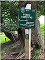
Image Listing (12 Images Found)
Images are licensed for reuse under creativecommons.org/licenses/by-sa/2.0
Image
Details
Distance
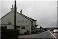
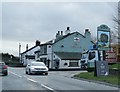
2

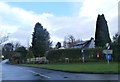
Butley Town
One of the smallest towns in England
Image: © Chris Morgan
Taken: 5 Jul 2021
0.10 miles
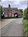
3
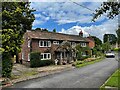
Little Danby Cottage, Well Lane
In the hamlet of Butley Town near Prestbury
Image: © Graham Hogg
Taken: 5 Jul 2021
0.10 miles
9
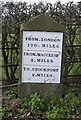
Old Milestone by the A523, south of Butley Town
Metal plate attached to stone post by the A523, in parish of Prestbury (Macclesfield District), London Road; South of Prestbury Lane junction, opposite Aldersey Fold, in front of hedge, on West side of road. London Road iron plate, erected by the Macclesfield District of Sandon & Bullock Smithy turnpike trust in the 19th century.
Inscription reads:-
FROM.LONDON
170 . MILES
------
FROM.MACCLESFᴰ.
3 . MILES
------
TO.STOCKPORT
9 . MILES.
Carved benchmark on lower face.
Grade II listed.
List Entry Number: 1139572 https://historicengland.org.uk/listing/the-list/list-entry/1139572
Milestone Society National ID: CH_MFSK03
Image: © Mike Faherty
Taken: 19 Mar 2007
0.17 miles
10
Peak & Northern Footpath Sign No 559
One of the most recent P&R signs - with a dedication to Mike Hoare (1947 - 2017). This signpost is located close to Whiteley Hey Farm
http://www.peakandnorthern.org.uk/signposts/about-our-signposts.htm
Image: © Philip Cornwall
Taken: 30 Aug 2020
0.23 miles