IMAGES TAKEN NEAR TO
Bonis Hall Lane, MACCLESFIELD, SK10 4DT
Introduction
This page details the photographs taken nearby to Bonis Hall Lane, SK10 4DT by members of the Geograph project.
The Geograph project started in 2005 with the aim of publishing, organising and preserving representative images for every square kilometre of Great Britain, Ireland and the Isle of Man.

There are currently over 7.5m images from over14,400 individuals and you can help contribute to the project by visiting https://www.geograph.org.uk
Image Map
Images are licensed for reuse under creativecommons.org/licenses/by-sa/2.0
Notes
- Clicking on the map will re-center to the selected point.
- The higher the marker number, the further away the image location is from the centre of the postcode.
Image Listing (8 Images Found)
Images are licensed for reuse under creativecommons.org/licenses/by-sa/2.0
Image
Details
Distance
1
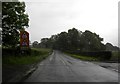
Bonis Hall Lane by junction with Butley Lane
Image: © Peter Bond
Taken: 23 Jun 2011
0.05 miles
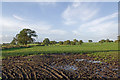
2
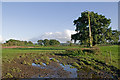
Off Butley Lanes
A field off Butley Lanes, near its junction with Bonis Hall Lane
Image: © Ian Capper
Taken: 5 Oct 2010
0.07 miles
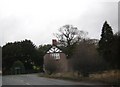
3
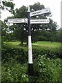
Old Direction Sign - Signpost by the B5358, Bonis Hall Lane, Prestbury Parish
Pawn finial - 3 arms; Cheshire New CCC octagonal by the B5358, in parish of Prestbury (Macclesfield District), junction of Bonis Hall Lane (B5358) and Butley Lanes.
To be surveyed
Milestone Society National ID: CH_SJ8978.
Image: © S Charles
Taken: 10 Jul 2015
0.09 miles
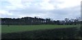
4
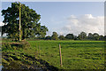
Off Butley Lanes
A field off Butley Lanes, near its junction with Bonis Hall Lane
Image: © Ian Capper
Taken: 5 Oct 2010
0.11 miles
5
Football pitch off Butley Lanes
A rather incongruous setting for a football pitch, surrounded by farmland and with no facilities.
Image: © Ian Capper
Taken: 5 Oct 2010
0.12 miles
6
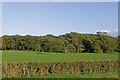
Towards Bonis Wood
Viewed from the B5358 Bonis Hall Lane
Image: © Ian Capper
Taken: 5 Oct 2010
0.19 miles
8
Fields over the Hedgerow - Bonis Hall Lane
Image: © Anthony Parkes
Taken: 9 Jan 2016
0.22 miles