IMAGES TAKEN NEAR TO
Summerhill Road, MACCLESFIELD, SK10 4AH
Introduction
This page details the photographs taken nearby to Summerhill Road, SK10 4AH by members of the Geograph project.
The Geograph project started in 2005 with the aim of publishing, organising and preserving representative images for every square kilometre of Great Britain, Ireland and the Isle of Man.

There are currently over 7.5m images from over14,400 individuals and you can help contribute to the project by visiting https://www.geograph.org.uk
Image Map (Loading...)


Getting Data...Please wait
Leaflet Map data © OpenStreetMap
Images are licensed for reuse under creativecommons.org/licenses/by-sa/2.0
Notes
- Clicking on the map will re-center to the selected point.
- The higher the marker number, the further away the image location is from the centre of the postcode.
Image Listing (1 Images Found)
Images are licensed for reuse under creativecommons.org/licenses/by-sa/2.0
Image
Details
Distance
1
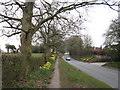
Macclesfield Road, Prestbury
Leaving the village behind and heading for the cross roads at Upton at the junction with Alderley Road. Heavy plantings of cultivated, not natural wild daffodils on the roads around Prestbury.
Image: © Peter Turner
Taken: 26 Mar 2011
0.15 miles