IMAGES TAKEN NEAR TO
Pleasant View, MACCLESFIELD, SK10 3LJ
Introduction
This page details the photographs taken nearby to Pleasant View, SK10 3LJ by members of the Geograph project.
The Geograph project started in 2005 with the aim of publishing, organising and preserving representative images for every square kilometre of Great Britain, Ireland and the Isle of Man.

There are currently over 7.5m images from over14,400 individuals and you can help contribute to the project by visiting https://www.geograph.org.uk
Image Map
Images are licensed for reuse under creativecommons.org/licenses/by-sa/2.0
Notes
- Clicking on the map will re-center to the selected point.
- The higher the marker number, the further away the image location is from the centre of the postcode.
Image Listing (19 Images Found)
Images are licensed for reuse under creativecommons.org/licenses/by-sa/2.0
Image
Details
Distance
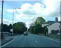
3
Power lines cross the A537 east of Henbury
Image: © Peter Whatley
Taken: 19 Jan 2012
0.04 miles
6
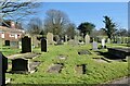
Around Henbury (3)
Graveyard: St Thomas's church
Image: © Anthony O'Neil
Taken: 27 Feb 2022
0.16 miles
7
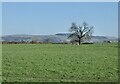
Around Henbury (6)
Meadows with a view towards Macclesfield Forest
Image: © Anthony O'Neil
Taken: 27 Feb 2022
0.16 miles
9
Around Henbury (4)
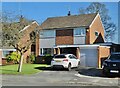
House at Henbury Rise
Image: © Anthony O'Neil
Taken: 27 Feb 2022
0.18 miles
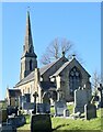
10
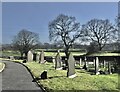
Henbury graveyard
Looking south east
Image: © Anthony O'Neil
Taken: 27 Feb 2022
0.19 miles