IMAGES TAKEN NEAR TO
Wightman Avenue, MACCLESFIELD, SK10 3GT
Introduction
This page details the photographs taken nearby to Wightman Avenue, SK10 3GT by members of the Geograph project.
The Geograph project started in 2005 with the aim of publishing, organising and preserving representative images for every square kilometre of Great Britain, Ireland and the Isle of Man.

There are currently over 7.5m images from over14,400 individuals and you can help contribute to the project by visiting https://www.geograph.org.uk
Image Map
Images are licensed for reuse under creativecommons.org/licenses/by-sa/2.0
Notes
- Clicking on the map will re-center to the selected point.
- The higher the marker number, the further away the image location is from the centre of the postcode.
Image Listing (22 Images Found)
Images are licensed for reuse under creativecommons.org/licenses/by-sa/2.0
Image
Details
Distance
3
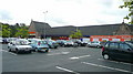
Sainsbury's, Macclesfield
Undergoing renovation.
Image: © Jonathan Billinger
Taken: 3 Sep 2008
0.16 miles
4
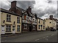
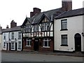
The Old Ship Inn
The Old Ship Inn on Beech Lane in Macclesfield.
Image: © Peter McDermott
Taken: 11 Jul 2015
0.16 miles
5
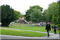
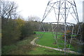
Play area and park
In west-central Macclesfield.
Image: © Jonathan Billinger
Taken: 3 Sep 2008
0.17 miles
6
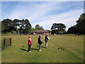
West Park, Macclesfield
The bowling green in West Park is cruciform in shape and the largest crown-green bowling green in the country.
Image: © Peter Turner
Taken: 4 May 2011
0.17 miles