IMAGES TAKEN NEAR TO
West Park Drive, MACCLESFIELD, SK10 3FU
Introduction
This page details the photographs taken nearby to West Park Drive, SK10 3FU by members of the Geograph project.
The Geograph project started in 2005 with the aim of publishing, organising and preserving representative images for every square kilometre of Great Britain, Ireland and the Isle of Man.

There are currently over 7.5m images from over14,400 individuals and you can help contribute to the project by visiting https://www.geograph.org.uk
Image Map
Images are licensed for reuse under creativecommons.org/licenses/by-sa/2.0
Notes
- Clicking on the map will re-center to the selected point.
- The higher the marker number, the further away the image location is from the centre of the postcode.
Image Listing (11 Images Found)
Images are licensed for reuse under creativecommons.org/licenses/by-sa/2.0
Image
Details
Distance
1
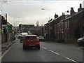
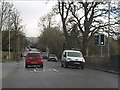
Chester Road approaches the Oxford Road roundabout
Image: © Peter Whatley
Taken: 19 Jan 2012
0.11 miles
2
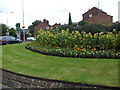
Sunflowers on Cumberland Street Roundabout
Image: © Glyn Drury
Taken: 6 Sep 2009
0.14 miles
3
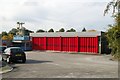
Macclesfield fire station
Macclesfield fire station, Chester Road, Macclesfield, Cheshire.
Image: © Kevin Hale
Taken: 23 Oct 2006
0.15 miles
4
B5087 at Macclesfield Crematorium entrance
Image: © Colin Pyle
Taken: 12 Oct 2019
0.17 miles
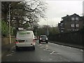
5
Traffic lights at the hospital entrance
Image: © Peter Whatley
Taken: 19 Jan 2012
0.20 miles
6
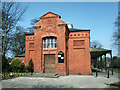
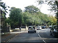
West Park Museum Entrance
A view of the entrance to West park Museum.
Image: © mike porter
Taken: 31 Mar 2003
0.20 miles
9

Pool at Macclesfield General Hospital
complete with resident ducks.
Image: © Neil Lewin
Taken: 13 Aug 2006
0.22 miles
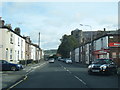
10
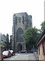
St. Albans Church, Chester Road
The Church of St Albans, located on Chester road.
Photograph was taken from Hall Street.
Image: © mike porter
Taken: 9 Jun 2003
0.24 miles