IMAGES TAKEN NEAR TO
Brynton Road, MACCLESFIELD, SK10 3AF
Introduction
This page details the photographs taken nearby to Brynton Road, SK10 3AF by members of the Geograph project.
The Geograph project started in 2005 with the aim of publishing, organising and preserving representative images for every square kilometre of Great Britain, Ireland and the Isle of Man.

There are currently over 7.5m images from over14,400 individuals and you can help contribute to the project by visiting https://www.geograph.org.uk
Image Map
Images are licensed for reuse under creativecommons.org/licenses/by-sa/2.0
Notes
- Clicking on the map will re-center to the selected point.
- The higher the marker number, the further away the image location is from the centre of the postcode.
Image Listing (20 Images Found)
Images are licensed for reuse under creativecommons.org/licenses/by-sa/2.0
Image
Details
Distance
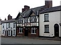
1
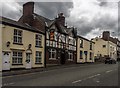
The Old Ship Inn
The Old Ship Inn on Beech Lane in Macclesfield.
Image: © Peter McDermott
Taken: 11 Jul 2015
0.11 miles
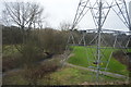
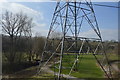
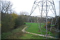
2
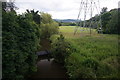
Football pitches under power lines
Beside the River Bollin, in Macclesfield.Pipelines cross the river.
Image: © Peter Barr
Taken: 30 Jun 2014
0.12 miles
7
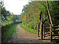
The Bollin Way, Macclesfield
A piece of public art (figure with bird) marks the start of this recreational riverside path.
Image: © michael ely
Taken: 16 Oct 2006
0.15 miles
9
Car showroom, Manchester Road
Where the road, the A538, crosses the River Bollin, in Macclesfield.
Image: © Peter Barr
Taken: 30 Jun 2014
0.17 miles