IMAGES TAKEN NEAR TO
Rainow Road, MACCLESFIELD, SK10 2PD
Introduction
This page details the photographs taken nearby to Rainow Road, SK10 2PD by members of the Geograph project.
The Geograph project started in 2005 with the aim of publishing, organising and preserving representative images for every square kilometre of Great Britain, Ireland and the Isle of Man.

There are currently over 7.5m images from over14,400 individuals and you can help contribute to the project by visiting https://www.geograph.org.uk
Image Map
Images are licensed for reuse under creativecommons.org/licenses/by-sa/2.0
Notes
- Clicking on the map will re-center to the selected point.
- The higher the marker number, the further away the image location is from the centre of the postcode.
Image Listing (15 Images Found)
Images are licensed for reuse under creativecommons.org/licenses/by-sa/2.0
Image
Details
Distance
1
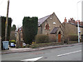
Former chapel
This building on Rainow Road is now in private ownership but bears the inscription "Ebenezer Chapel 1865".
Image: © Stephen Craven
Taken: 27 Dec 2011
0.01 miles
2
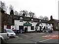
The George and Dragon
A pub on Rainow Road. It advertised real ales but it was too early in the day to be tempted.
Image: © Stephen Craven
Taken: 27 Dec 2011
0.02 miles
4
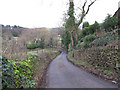
Well Lane
The lane is steeper than it may look here: an arrow on the map implies at least 1:7 (14%).
Image: © Stephen Craven
Taken: 27 Dec 2011
0.11 miles
5
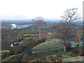
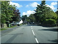
From Higher Hurdsfield heights
The roofs of the hamlet of Higher Hurdsfield are visible at the end of the ridge and beyond with its steam cloud the Pharmaceuticals factory of Astra-Zeneca and the Cheshire Plain stretching into the haze.
Image: © Peter Turner
Taken: 4 Feb 2003
0.13 miles
6
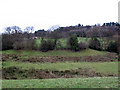
Field below Well Lane
This marshy land is in a hollow below Higher Hurdsfield village, and just across the lane from where a well is shown on the map.
Image: © Stephen Craven
Taken: 27 Dec 2011
0.13 miles
7
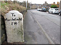
Milestone to Macclesfield
The uphill side of a milestone on Rainow Road, which is marked on the map. One mile to Macclesfield. The name has been written awkwardly, perhaps by whoever carved it in the first place with subsequent repainting highlighting the mistake.
Image: © Stephen Craven
Taken: 27 Dec 2011
0.16 miles
8

Milestone to Sheffield
The downhill side of a milestone on Rainow Road, which is marked on the map. See Image for the other side. "Chapel" is Chapel-en-le-Frith.
Image: © Stephen Craven
Taken: 27 Dec 2011
0.16 miles
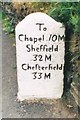
9
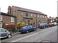
Former Sunday School
This large two-storey building on Rainow Road was formerly a Sunday School.
Image: © Stephen Craven
Taken: 27 Dec 2011
0.18 miles
10
Old Milestone by the B5470, Rainow Road, Higher Hurdsfield
Carved stone post by the B5470, in parish of Higher Hurdsfield (Macclesfield District), Rainow Road; opposite The Milehouse, No. 66, in pavement back to low stone wall, on South East side of road. Chapel Wedge, erected by the Macclesfield to Chapel en le Frith turnpike trust in the 18th century.
Inscription reads:-
: To / Macclesfield / 1 M : : To / Chapel 10 M / Sheffield / 32 M / Chesterfield / 33M :
Grade II listed.
List Entry Number: 1312763 https://historicengland.org.uk/listing/the-list/list-entry/1312763
Milestone Society National ID: CH_CFMF10
Image: © J Higgins
Taken: 1 Jul 2003
0.18 miles