IMAGES TAKEN NEAR TO
Snape Road, MACCLESFIELD, SK10 2NZ
Introduction
This page details the photographs taken nearby to Snape Road, SK10 2NZ by members of the Geograph project.
The Geograph project started in 2005 with the aim of publishing, organising and preserving representative images for every square kilometre of Great Britain, Ireland and the Isle of Man.

There are currently over 7.5m images from over14,400 individuals and you can help contribute to the project by visiting https://www.geograph.org.uk
Image Map
Images are licensed for reuse under creativecommons.org/licenses/by-sa/2.0
Notes
- Clicking on the map will re-center to the selected point.
- The higher the marker number, the further away the image location is from the centre of the postcode.
Image Listing (9 Images Found)
Images are licensed for reuse under creativecommons.org/licenses/by-sa/2.0
Image
Details
Distance
1

Booker cash and carry
On Queens Avenue, Hurdsfield, Macclesfield. 180-degree view from Image
Image: © Jonathan Billinger
Taken: 3 Sep 2008
0.12 miles
2
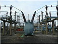
Substation machinery
Within the electricity substation at Hurdsfield, Macclesfield.
Image: © Jonathan Billinger
Taken: 16 Dec 2008
0.15 miles
3
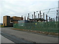
Electricity substation, Hurdsfield
To the east of Macclesfield town centre.
Image: © Jonathan Billinger
Taken: 16 Dec 2008
0.15 miles
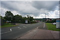
5
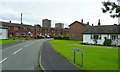
Chestnut Avenue, Hurdsfield
Low and high-rise housing in this eastern suburb of Macclesfield.
Image: © Jonathan Billinger
Taken: 3 Sep 2008
0.18 miles
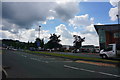
6
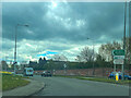
Astra Zeneca and other companies
Hurdsfield Industrial Estate, Hulley Road, Macclesfield.
Image: © Peter Barr
Taken: 30 Jun 2014
0.18 miles
7
Hurdsfield Industrial Estate
Hulley Road, Macclesfield.
Image: © Peter Barr
Taken: 30 Jun 2014
0.20 miles
8

New warehousing
Off Queens Avenue, Hurdsfield, Macclesfield.
Image: © Jonathan Billinger
Taken: 3 Sep 2008
0.21 miles
9

Pylons, Macclesfield
From the left the power lines have crossed above the "Silk Road" (A523), then head towards the Hurdsfield Industrial Estate out of sight right.
Image: © Carl Farnell
Taken: 19 Jun 2011
0.23 miles