IMAGES TAKEN NEAR TO
Dale Street, MACCLESFIELD, SK10 1NH
Introduction
This page details the photographs taken nearby to Dale Street, SK10 1NH by members of the Geograph project.
The Geograph project started in 2005 with the aim of publishing, organising and preserving representative images for every square kilometre of Great Britain, Ireland and the Isle of Man.

There are currently over 7.5m images from over14,400 individuals and you can help contribute to the project by visiting https://www.geograph.org.uk
Image Map
Images are licensed for reuse under creativecommons.org/licenses/by-sa/2.0
Notes
- Clicking on the map will re-center to the selected point.
- The higher the marker number, the further away the image location is from the centre of the postcode.
Image Listing (144 Images Found)
Images are licensed for reuse under creativecommons.org/licenses/by-sa/2.0
Image
Details
Distance
1
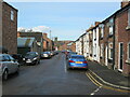
Flint Street, Macclesfield
Looking towards Buxton Road A537 from Fountain Street.
Image: © Robin Stott
Taken: 27 Apr 2011
0.05 miles
2
Hallefield Crescent, Macclesfield
Hovis Mill flats in the background.
Image: © Robin Stott
Taken: 27 Apr 2011
0.06 miles
3
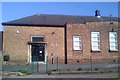
Morton Jubilee Hall, Union Road, Macclesfield
A community centre with a hall and other rooms for hire. Built in 1939 as a social club for the workers at the nearby Hovis Mill, the large basement served as an air-raid shelter in World War II. http://www.mortonhallcommunitycentre.org/
Image: © Robin Stott
Taken: 27 Apr 2011
0.08 miles
4
Vacant showroom with Art Deco clock, Macclesfield
On the corner of Union Road and Buxton Road A537. A closer view of the clock is Image
Photographed with an early iPhone. On the computer, exposure has been increased, sharpening applied, and colour temperature increased to counter a blue cast
Image: © Robin Stott
Taken: 27 Apr 2011
0.08 miles
5
Art Deco clock on a showroom, Macclesfield
A closer look at the clock in Image, from a higher vantage point up the Buxton Road.
Photographed against the light with an iPhone 4S a little beyond the limits of its digital zoom. On the computer, highlights have been reduced to dull down the reflections (and darken the sky), and some sharpening applied.
Image: © Robin Stott
Taken: 12 Nov 2011
0.08 miles
6
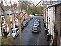
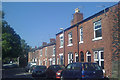
Hope Street, Macclesfield
Seen over the wall of Fountain Mews. This is an area of former silk mill-workers' 2-up 2-down houses. The 3-storey house, right, suggests a weaver's house, with its wide second floor window to give plenty of light for weaving by. The view is towards the Buxton Road, A537.
Image: © Robin Stott
Taken: 4 Dec 2009
0.08 miles
7
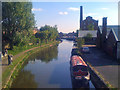
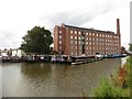
Macclesfield Canal, Macclesfield: 2
Looking south from the Buxton Road bridge, A537. The redundant chimney is attached to the Hovis Mill, now a block of flats.
Image: © Robin Stott
Taken: 27 Apr 2011
0.08 miles
8
Fountain Street, Macclesfield
A street near Buxton Road, east of the town centre. In the distance is the tower of St Michael and All Angels Church.
Image: © David Weston
Taken: 24 Mar 2021
0.08 miles
9
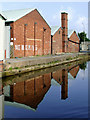
Wharf and Industrial units in Macclesfield, Cheshire
These buildings are by the Macclesfield Canal south of Buxton Road Bridge, No 37.
Image: © Roger D Kidd
Taken: 5 Sep 2014
0.09 miles