IMAGES TAKEN NEAR TO
Willerby Close, MACCLESFIELD, SK10 1DZ
Introduction
This page details the photographs taken nearby to Willerby Close, SK10 1DZ by members of the Geograph project.
The Geograph project started in 2005 with the aim of publishing, organising and preserving representative images for every square kilometre of Great Britain, Ireland and the Isle of Man.

There are currently over 7.5m images from over14,400 individuals and you can help contribute to the project by visiting https://www.geograph.org.uk
Image Map
Images are licensed for reuse under creativecommons.org/licenses/by-sa/2.0
Notes
- Clicking on the map will re-center to the selected point.
- The higher the marker number, the further away the image location is from the centre of the postcode.
Image Listing (27 Images Found)
Images are licensed for reuse under creativecommons.org/licenses/by-sa/2.0
Image
Details
Distance
2
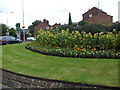
Sunflowers on Cumberland Street Roundabout
Image: © Glyn Drury
Taken: 6 Sep 2009
0.05 miles
3
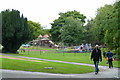
Play area and park
In west-central Macclesfield.
Image: © Jonathan Billinger
Taken: 3 Sep 2008
0.11 miles
4
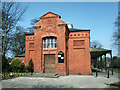
West Park Museum Entrance
A view of the entrance to West park Museum.
Image: © mike porter
Taken: 31 Mar 2003
0.11 miles
5
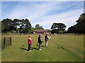
West Park, Macclesfield
The bowling green in West Park is cruciform in shape and the largest crown-green bowling green in the country.
Image: © Peter Turner
Taken: 4 May 2011
0.11 miles
6
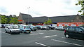
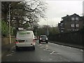
Sainsbury's, Macclesfield
Undergoing renovation.
Image: © Jonathan Billinger
Taken: 3 Sep 2008
0.12 miles
8
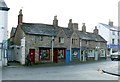
1 ? 7 Chester Road
Early 17th century with later alterations, possibly built as a single dwelling. The shops would have been inserted probably in the late 19th century. It is roofed with traditional graduated stone flags. Listed Grade II.
Image: © Alan Murray-Rust
Taken: 25 Jan 2018
0.14 miles
9
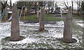
Old Wayside Crosses
West Park Crosses, the shafts of three moved wayside crosses. Set in West Park off Prestbury Road in Macclesfield parish. Scheduled Monument https://historicengland.org.uk/listing/the-list/list-entry/1012884. See also http://www.megalithic.co.uk/article.php?sid=7471.
Milestone Society National ID: CHMA_MAC02
Image: © D Garside
Taken: Unknown
0.15 miles
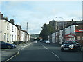
10
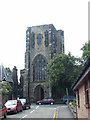
St. Albans Church, Chester Road
The Church of St Albans, located on Chester road.
Photograph was taken from Hall Street.
Image: © mike porter
Taken: 9 Jun 2003
0.15 miles