IMAGES TAKEN NEAR TO
Pownall Street, MACCLESFIELD, SK10 1DG
Introduction
This page details the photographs taken nearby to Pownall Street, SK10 1DG by members of the Geograph project.
The Geograph project started in 2005 with the aim of publishing, organising and preserving representative images for every square kilometre of Great Britain, Ireland and the Isle of Man.

There are currently over 7.5m images from over14,400 individuals and you can help contribute to the project by visiting https://www.geograph.org.uk
Image Map
Images are licensed for reuse under creativecommons.org/licenses/by-sa/2.0
Notes
- Clicking on the map will re-center to the selected point.
- The higher the marker number, the further away the image location is from the centre of the postcode.
Image Listing (58 Images Found)
Images are licensed for reuse under creativecommons.org/licenses/by-sa/2.0
Image
Details
Distance
4
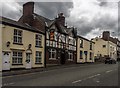
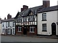
The Old Ship Inn
The Old Ship Inn on Beech Lane in Macclesfield.
Image: © Peter McDermott
Taken: 11 Jul 2015
0.09 miles
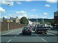
6
Hibel Road/Beech Lane/Jordangate junction
The two blocks of the Hurdsfield flats reach up to the skyline of the Kerridge ridge behind the redbrick square of the Magistrate's Court building.
Image: © Peter Turner
Taken: 22 Jan 2003
0.11 miles
7
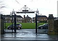
Gateway of Remembrance, King's School
The school will move to a new site adjacent to its playing fields on Alderley Road in around 2020 when the current site is due to be developed as housing.
Image: © Alan Murray-Rust
Taken: 25 Jan 2018
0.13 miles
8
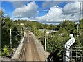
Macclesfield Hibel Road railway station (site), Cheshire
Opened in 1849 by the London & North Western Railway on what is now the line from Manchester to Stafford, this station closed in 1960 when services were transferred to the current station some 500m south of here, behind the camera position.
View north from Hibel Road bridge, where the booking office was located. The whole location was very cramped, with an engine shed and turntable having been located on the right of the image.
The bare patch of ground centre right was the approximate site of a temporary passenger station when the line from Marple was opened in 1869. The LNWR weren't interested in having a joint station, so services were transferred to a new "Central" station (where the current Macclesfield station is) in 1873 but the 1869 station continued as a good station until 1969.
Image: © Nigel Thompson
Taken: 4 Oct 2021
0.16 miles
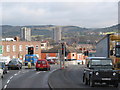
10

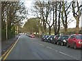
Macclesfield - Cumberland Street at Westminster Road roundabout
Image: © Peter Whatley
Taken: 19 Jan 2012
0.17 miles