IMAGES TAKEN NEAR TO
Baldock Road, ROYSTON, SG8 9NR
Introduction
This page details the photographs taken nearby to Baldock Road, SG8 9NR by members of the Geograph project.
The Geograph project started in 2005 with the aim of publishing, organising and preserving representative images for every square kilometre of Great Britain, Ireland and the Isle of Man.

There are currently over 7.5m images from over14,400 individuals and you can help contribute to the project by visiting https://www.geograph.org.uk
Image Map
Images are licensed for reuse under creativecommons.org/licenses/by-sa/2.0
Notes
- Clicking on the map will re-center to the selected point.
- The higher the marker number, the further away the image location is from the centre of the postcode.
Image Listing (18 Images Found)
Images are licensed for reuse under creativecommons.org/licenses/by-sa/2.0
Image
Details
Distance
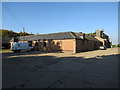
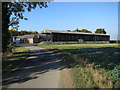
3
At Morden Grange Farm
A public bridle path passes through the yard.
Image: © John Sutton
Taken: 21 Mar 2017
0.02 miles
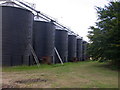
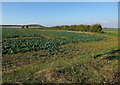
5
Silos at Morden Grange Farm
A March day of high broken cloud, which the sun was temporarily behind. Oilseed rape was just coming into flower in the field to the right of the bridle path.
Image: © John Sutton
Taken: 21 Mar 2017
0.05 miles
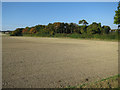
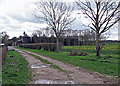
6
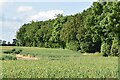
Belt of trees around Morden Grange Farm
Image: © David Martin
Taken: 25 May 2024
0.06 miles
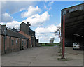
7
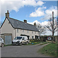
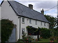
Cottages at Morden Grange Farm
Just north of the farm, on the bridle way to Ashwell Street and Litlington.
Image: © John Sutton
Taken: 21 Mar 2017
0.07 miles