IMAGES TAKEN NEAR TO
Ryecroft Lane, ROYSTON, SG8 7TT
Introduction
This page details the photographs taken nearby to Ryecroft Lane, SG8 7TT by members of the Geograph project.
The Geograph project started in 2005 with the aim of publishing, organising and preserving representative images for every square kilometre of Great Britain, Ireland and the Isle of Man.

There are currently over 7.5m images from over14,400 individuals and you can help contribute to the project by visiting https://www.geograph.org.uk
Image Map
Images are licensed for reuse under creativecommons.org/licenses/by-sa/2.0
Notes
- Clicking on the map will re-center to the selected point.
- The higher the marker number, the further away the image location is from the centre of the postcode.
Image Listing (119 Images Found)
Images are licensed for reuse under creativecommons.org/licenses/by-sa/2.0
Image
Details
Distance
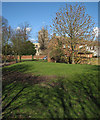
1
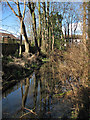
Fowlmere: the Round Moat
The nearby information board explains that the Fowlmere moat is unusual in being oval, one of only four in the county. Its size and substantial earthworks suggest an important builder, perhaps in the 11th century. "Wet until the 1980s, it held water for almost 1,000 years," reads the board, "but the general lowering of the water table in recent years has now left the moat completely dry." That is no longer the case after the exceptionally wet summer of 2012 and the record rainfall of winter 2014.
Image: © John Sutton
Taken: 16 Feb 2014
0.08 miles
2
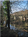
Fowlmere: Round Moat and the backs of houses
The nearby information board explains that the Fowlmere moat is unusual in being oval, one of only four in the county. Its size and substantial earthworks suggest an important builder, perhaps in the 11th century. "Wet until the 1980s, it held water for almost 1,000 years," reads the board, "but the general lowering of the water table in recent years has now left the moat completely dry." That is no longer the case after the exceptionally wet summer of 2012 and the record rainfall of winter 2014.
The houses on the other side of the moat are on Saville Way, part of a modern development south of the church.
Image: © John Sutton
Taken: 16 Feb 2014
0.08 miles
6
Fowlmere: towards the church
A view from the open space between Savile Way (ahead) and St Mary's Way.
Image: © John Sutton
Taken: 16 Feb 2014
0.12 miles
7
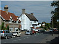
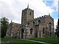
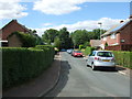
Fowlmere village, Cambridgeshire.
A pretty Cambridgeshire village.
Image: © Andy Peacock
Taken: 31 Aug 2002
0.13 miles
8
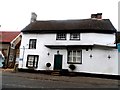
Former Chequers pub, Fowlmere
Closed up and for sale. Note the inscription above the door "Ano Dom 1675". See http://www.geograph.org.uk/photo/801304 for another view from 2008 with historical information.
Image: © Bikeboy
Taken: 2 Dec 2013
0.14 miles