IMAGES TAKEN NEAR TO
Pipers Close, ROYSTON, SG8 7RX
Introduction
This page details the photographs taken nearby to Pipers Close, SG8 7RX by members of the Geograph project.
The Geograph project started in 2005 with the aim of publishing, organising and preserving representative images for every square kilometre of Great Britain, Ireland and the Isle of Man.

There are currently over 7.5m images from over14,400 individuals and you can help contribute to the project by visiting https://www.geograph.org.uk
Image Map
Images are licensed for reuse under creativecommons.org/licenses/by-sa/2.0
Notes
- Clicking on the map will re-center to the selected point.
- The higher the marker number, the further away the image location is from the centre of the postcode.
Image Listing (40 Images Found)
Images are licensed for reuse under creativecommons.org/licenses/by-sa/2.0
Image
Details
Distance
1
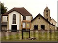
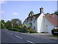
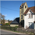
Manor Farm Road, Fowlmere
This view from Manor Farm Road shows Piper's Close on the B1368 road through Fowlmere.The URC chapel is to the left.Most of these houses were formerly council houses.
Image: © David Beresford
Taken: 13 Jan 2013
0.02 miles
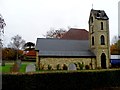
3
Fowlmere and Thriplow United Reformed Church
The building of this church began in 1780 and it seen many changes since then.
Image: © Robert Edwards
Taken: 11 Jul 2007
0.07 miles
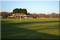
4
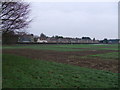
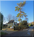
Soggy Christmas in Fowlmere
View of experimental plots on Manor Farm, Fowlmere. Picture taken at midday on Christmas Day 2012 at end of long wet year.
Image: © David Beresford
Taken: 25 Dec 2012
0.07 miles
5
Cottages in Pipers Lane
The tower of the United Reformed Church can be seen over the far end.
Image: © Keith Edkins
Taken: 14 May 2008
0.08 miles
6
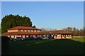
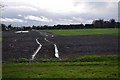
Fowlmere village hall
Costs of upkeep make it difficult to keep this facility open. Its committee and supporters have to work hard to keep it going.
Image: © David Beresford
Taken: 9 Jan 2013
0.08 miles
7
Fowlmere village hall
Village hall viewed across its playing fields.
Image: © David Beresford
Taken: 9 Jan 2013
0.08 miles
8
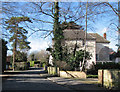
Fowlmere: Chapel Lane
The house on the right, White Hall, dates from 1658, with 18th- and 19th-century additions and alterations. It is Grade II listed - see http://www.britishlistedbuildings.co.uk/en-52918-white-hall-fowlmere-cambridgeshire .
Image: © John Sutton
Taken: 16 Feb 2014
0.09 miles
9
Fowlmere: the tower of the United Reformed Church
The chapel dates from 1780 and the main part of it is timber-framed and rendered. The yellow-brick tower dates from 1881. For its British Listed Buildings citation, see http://www.britishlistedbuildings.co.uk/en-52915-united-reformed-church-and-memorial-stone . Image] shows the north side of the building.
Image: © John Sutton
Taken: 16 Feb 2014
0.09 miles
10
Fowlmere: Chapel Lane and Perks Close
The bright morning of Boxing Day. The Grade II listing for Perks Close begins "Late C15 or early C16 with late C17 alterations. Timber-framed and partly plastered. Thatched roofs half hipped to right hand."
Image: © John Sutton
Taken: 26 Dec 2022
0.10 miles