IMAGES TAKEN NEAR TO
Burtons, ROYSTON, SG8 6NQ
Introduction
This page details the photographs taken nearby to Burtons, SG8 6NQ by members of the Geograph project.
The Geograph project started in 2005 with the aim of publishing, organising and preserving representative images for every square kilometre of Great Britain, Ireland and the Isle of Man.

There are currently over 7.5m images from over14,400 individuals and you can help contribute to the project by visiting https://www.geograph.org.uk
Image Map
Images are licensed for reuse under creativecommons.org/licenses/by-sa/2.0
Notes
- Clicking on the map will re-center to the selected point.
- The higher the marker number, the further away the image location is from the centre of the postcode.
Image Listing (11 Images Found)
Images are licensed for reuse under creativecommons.org/licenses/by-sa/2.0
Image
Details
Distance
1
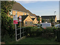
Burtons, Meldreth
New housing on the edge of the village.
Image: © Hugh Venables
Taken: 17 Jul 2014
0.01 miles
2
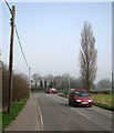
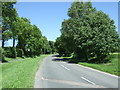
Meldreth: nearing the crossroads
The oncoming car is on Kneesworth Road and another is turning into Whitecroft Road, which leads to the railway station and on to Melbourn. Whaddon Road is to the left, Fenny Lane straight ahead. The sun had broken through morning fog only a few moments earlier.
Image: © John Sutton
Taken: 13 Mar 2014
0.12 miles
3
Meldreth: a stinkpipe on Kneesworth Road
The sewer vent pipe on the right is one of seven in the village, six of them, like this one, the substantial utilitarian concrete-cased pipes found in several other South Cambridgeshire villages.
The others:
Image]
Image]
Image]
Image]
Image]
Image]
For more about Meldreth’s stinkpipes, try the informative village website: https://www.meldrethhistory.org.uk/the-village/village-wide_information/stink_stench_pipes_of_meldreth .
Image: © John Sutton
Taken: 25 Mar 2021
0.12 miles
4
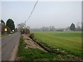
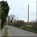
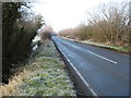
Nearing Meldreth on Kneesworth Road
At twenty past twelve the sun was beginning to break through fog which had been slow to shift. Compare this picture with Image], taken a little further down the road a few minutes later, and Image] from five minutes earlier.
Image: © John Sutton
Taken: 13 Mar 2014
0.14 miles
9
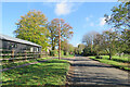
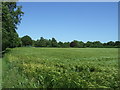
Meldreth: on Fenny Lane
A bright morning in early November. Fenny Lane Barns are on the left.
Image: © John Sutton
Taken: 4 Nov 2022
0.21 miles