IMAGES TAKEN NEAR TO
Meadow Way, ROYSTON, SG8 6EA
Introduction
This page details the photographs taken nearby to Meadow Way, SG8 6EA by members of the Geograph project.
The Geograph project started in 2005 with the aim of publishing, organising and preserving representative images for every square kilometre of Great Britain, Ireland and the Isle of Man.

There are currently over 7.5m images from over14,400 individuals and you can help contribute to the project by visiting https://www.geograph.org.uk
Image Map
Images are licensed for reuse under creativecommons.org/licenses/by-sa/2.0
Notes
- Clicking on the map will re-center to the selected point.
- The higher the marker number, the further away the image location is from the centre of the postcode.
Image Listing (85 Images Found)
Images are licensed for reuse under creativecommons.org/licenses/by-sa/2.0
Image
Details
Distance
1
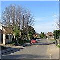
Melbourn: a stinkpipe on Orchard Road
To the left of the red car, half-hidden by branches, is one of the concrete-cased sewer vent pipes found in a number of villages in this part of Cambridgeshire.
Other stinkpipes in Melbourn:
Image]
Image]
Image]
Image]
Image]
Image]
Image]
For links to pictures of stinkpipes in nearby Meldreth, see Image
Image: © John Sutton
Taken: 30 Mar 2021
0.07 miles
2
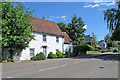
Melbourn High Street: a listed house
This Grade II listed timber-framed house dates from about 1770.
Image: © John Sutton
Taken: 13 Jun 2020
0.09 miles
3
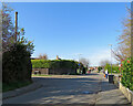
Melbourn: the corner of Orchard Road and Orchard Way
On the left, poking above the bushes, is one of the concrete-cased sewer vent pipes found in a number of villages in this part of Cambridgeshire.
Other stinkpipes in Melbourn:
Image]
Image]
Image]
Image]
Image]
Image]
Image]
For links to pictures of stinkpipes in nearby Meldreth, see Image
Image: © John Sutton
Taken: 30 Mar 2021
0.10 miles
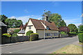
4
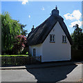
Melbourn: plaster and thatch, Norgett's Lane
This Grade II listed timber-framed house dates from the late 18th century.
Image: © John Sutton
Taken: 13 Jun 2020
0.10 miles
5
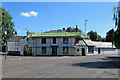
Melbourn: building work
The Grade II listing begins "House, formerly inn and shop, c 1840 and later. Brick or clay bat, stuccoed. Hipped roof of slate and grey-brick side stacks. House of double-pile plan with wings at either end for carriageway entry and a shop".
Image: © John Sutton
Taken: 13 Jun 2020
0.11 miles
7
Melbourn: a 17th-century house on Cambridge Road
This is a 17th-century timber-framed house with later additions and alterations.
Image: © John Sutton
Taken: 13 Jun 2020
0.13 miles
8
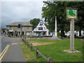
Melbourn: Village sign and War Memorial
The village sign reflects the history and strength of religious dissention in the area.
Image: © Nigel Cox
Taken: 6 Jul 2008
0.14 miles
9
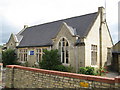
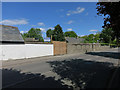
Melbourn County Primary School
The School is on the east side of Mortlock Street.
Image: © Nigel Cox
Taken: 6 Jul 2008
0.14 miles
10
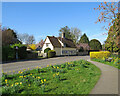
Melbourn: spring yellow, Cambridge Road
Taken in June 2020, Image] is a comparable picture of this timber-framed house.
Image: © John Sutton
Taken: 30 Mar 2021
0.14 miles