
IMAGES TAKEN NEAR TO
High Street, ROYSTON, SG8 6AL
Introduction
This page details the photographs taken nearby to High Street, SG8 6AL by members of the Geograph project.
The Geograph project started in 2005 with the aim of publishing, organising and preserving representative images for every square kilometre of Great Britain, Ireland and the Isle of Man.

There are currently over 7.5m images from over14,400 individuals and you can help contribute to the project by visiting https://www.geograph.org.uk
Image Map
Images are licensed for reuse under creativecommons.org/licenses/by-sa/2.0
Notes
- Clicking on the map will re-center to the selected point.
- The higher the marker number, the further away the image location is from the centre of the postcode.
Image Listing (39 Images Found)
Images are licensed for reuse under creativecommons.org/licenses/by-sa/2.0
Image
Details
Distance
1
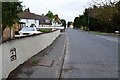
Old Milepost
The cast iron plaque lower left of photo from an old milepost now saved and mounted into the plaster of a garden wall on what was the A10 at Melbourn, Cambridgeshire. For close up view see http://www.geograph.org.uk/photo/5525925
Image: © Keith Evans
Taken: 29 Jun 2017
0.02 miles
2
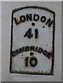
Old Milepost in High Street, Melbourn
Metal plate detached from post by the UC road, in parish of Melbourn (South Cambridgeshire District), Royston Road, by No. 106, opposite Greenbanks, on wall, on West side of road. Erected by the Hauxton & Dunsbridge turnpike trust in the 19th century.
Inscription reads:-
LONDON
41
CAMBRIDGE
10
Grade II listed.
List Entry Number: 1331227 https://historicengland.org.uk/listing/the-list/list-entry/1331227
Milestone Society National ID: CA_LK41
Image: © MW Hallett
Taken: 30 Dec 2002
0.02 miles
3
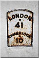
Old Milepost
The cast iron plaque from an old milepost now saved and mounted into the plaster of a garden wall on what was the A10 at Melbourn, Cambridgeshire. For overall view see http://www.geograph.org.uk/photo/5525926
Image: © Keith Evans
Taken: 29 Jun 2017
0.03 miles
4
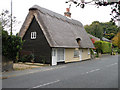
Turnpike Cottage, High Street
The listed building database has it as Tollgate Cottage. Late C17 and C19. Timber framed, roughcast rendered. Long straw thatch with original red brick axial ridge stack. Grade II listed, LBS number 52211. http://www.heritagegateway.org.uk/Gateway/Results_Single.aspx?uid=52211&resourceID=5
Image: © Keith Edkins
Taken: 13 Oct 2008
0.04 miles
5
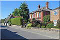
Melbourn: High Street contrasts
From left to right: Grade II listed Tollgate Cottage, dating from the late 17th century, a solid red-brick Victorian villa, and to its right something more recent.
Image: © John Sutton
Taken: 9 Aug 2022
0.04 miles
6
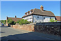
Melbourn: on High Street
The Grade II listed red-brick house on the left, originally a stable block, dates from a rebuilding in the middle of the 18th century. The white house is not listed.
Image: © John Sutton
Taken: 9 Aug 2022
0.05 miles
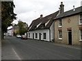
8
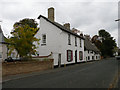
Red Cow, High Street
No doubt a former pub, it still has the name on a plate by the door.
Image: © Keith Edkins
Taken: 13 Oct 2008
0.09 miles
9
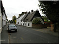
The Thatched House, High Street
Two building periods in C17 or C18. Timber framed, rendered and long straw thatch. Grade II listed, LBS number 52210. http://www.heritagegateway.org.uk/Gateway/Results_Single.aspx?uid=52210&resourceID=5
Image: © Keith Edkins
Taken: 13 Oct 2008
0.10 miles
10
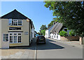
Melbourn: at the corner of Falconer Court
The thatched house on the right, The Thatched House, is Grade II listed and was built as two cottages.
Image: © John Sutton
Taken: 9 Aug 2022
0.10 miles