IMAGES TAKEN NEAR TO
Meldreth Road, ROYSTON, SG8 5RS
Introduction
This page details the photographs taken nearby to Meldreth Road, SG8 5RS by members of the Geograph project.
The Geograph project started in 2005 with the aim of publishing, organising and preserving representative images for every square kilometre of Great Britain, Ireland and the Isle of Man.

There are currently over 7.5m images from over14,400 individuals and you can help contribute to the project by visiting https://www.geograph.org.uk
Image Map
Images are licensed for reuse under creativecommons.org/licenses/by-sa/2.0
Notes
- Clicking on the map will re-center to the selected point.
- The higher the marker number, the further away the image location is from the centre of the postcode.
Image Listing (12 Images Found)
Images are licensed for reuse under creativecommons.org/licenses/by-sa/2.0
Image
Details
Distance
1
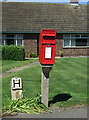
Elizabeth II postbox on Meldreth Road, Whaddon
Postbox No. SG8 322.
See Image] for context.
Image: © JThomas
Taken: 10 Jun 2017
0.04 miles
2
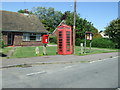
Elizabeth II postbox and telephone box on Meldreth Road, Whaddon
Postbox No. SG8 322.
See Image] for postbox.
Image: © JThomas
Taken: 10 Jun 2017
0.04 miles
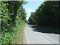
3
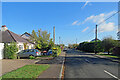
Whaddon: Meldreth Road
Ribbon development on the road from Whaddon to Meldreth (ahead).
Image: © John Sutton
Taken: 4 Nov 2022
0.04 miles
6
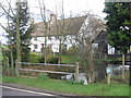
Attractive cottage beside stream in Whaddon
Image: © Alan Kent
Taken: 21 Feb 2007
0.10 miles