IMAGES TAKEN NEAR TO
South End, ROYSTON, SG8 5NG
Introduction
This page details the photographs taken nearby to South End, SG8 5NG by members of the Geograph project.
The Geograph project started in 2005 with the aim of publishing, organising and preserving representative images for every square kilometre of Great Britain, Ireland and the Isle of Man.

There are currently over 7.5m images from over14,400 individuals and you can help contribute to the project by visiting https://www.geograph.org.uk
Image Map
Images are licensed for reuse under creativecommons.org/licenses/by-sa/2.0
Notes
- Clicking on the map will re-center to the selected point.
- The higher the marker number, the further away the image location is from the centre of the postcode.
Image Listing (101 Images Found)
Images are licensed for reuse under creativecommons.org/licenses/by-sa/2.0
Image
Details
Distance
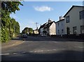
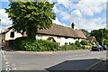
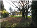
3
Bassingbourn: the north end of South End
A pleasing row near the High Street end of the road, one of them Grade II listed.
Image: © John Sutton
Taken: 9 Mar 2018
0.01 miles
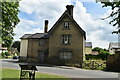
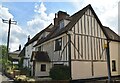
6
Old houses in Bassingbourn
These houses stand on a road called South End.
Image: © Robert Edwards
Taken: 8 Jun 2007
0.02 miles
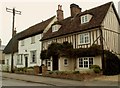
7
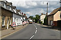
Bassingbourn High Street
Looking towards the junction at the west end of the High Street on a March morning.
Image: © John Sutton
Taken: 9 Mar 2018
0.02 miles
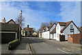
9
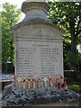
War memorial, Bassingbourn
Close up of the names of those from the village who fell in WWI. See Image
Image: © Hugh Venables
Taken: 27 Apr 2011
0.03 miles