IMAGES TAKEN NEAR TO
Ermine Way, ROYSTON, SG8 0AQ
Introduction
This page details the photographs taken nearby to Ermine Way, SG8 0AQ by members of the Geograph project.
The Geograph project started in 2005 with the aim of publishing, organising and preserving representative images for every square kilometre of Great Britain, Ireland and the Isle of Man.

There are currently over 7.5m images from over14,400 individuals and you can help contribute to the project by visiting https://www.geograph.org.uk
Image Map
Images are licensed for reuse under creativecommons.org/licenses/by-sa/2.0
Notes
- Clicking on the map will re-center to the selected point.
- The higher the marker number, the further away the image location is from the centre of the postcode.
Image Listing (16 Images Found)
Images are licensed for reuse under creativecommons.org/licenses/by-sa/2.0
Image
Details
Distance
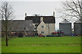
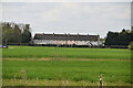
2
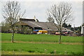
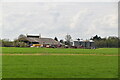
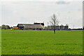
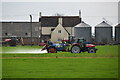
Eight Elms Farm
A telephoto shot taken from the side of the A1198 Ermine Street on a bright December morning.
Image: © John Sutton
Taken: 8 Dec 2022
0.01 miles
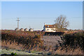
8
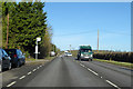
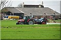
A1198, Ermine Way, heading north
The Roman Ermine Street. Hidden behind the bus stop is the village sign for the start of Arrington.
Image: © Robin Webster
Taken: 12 Feb 2018
0.12 miles