IMAGES TAKEN NEAR TO
Merchants Walk, BALDOCK, SG7 6TJ
Introduction
This page details the photographs taken nearby to Merchants Walk, SG7 6TJ by members of the Geograph project.
The Geograph project started in 2005 with the aim of publishing, organising and preserving representative images for every square kilometre of Great Britain, Ireland and the Isle of Man.

There are currently over 7.5m images from over14,400 individuals and you can help contribute to the project by visiting https://www.geograph.org.uk
Image Map
Images are licensed for reuse under creativecommons.org/licenses/by-sa/2.0
Notes
- Clicking on the map will re-center to the selected point.
- The higher the marker number, the further away the image location is from the centre of the postcode.
Image Listing (5 Images Found)
Images are licensed for reuse under creativecommons.org/licenses/by-sa/2.0
Image
Details
Distance
2
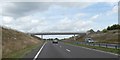
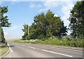
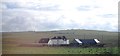
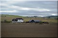
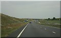
Farm track and footpath bridge over A505 outside Baldock
The farm track has been diverted from its former route, which would have crossed the A505 at about the photographer's location. Now it runs beside the A505 on the left, crosses the dual carriageway and then returns parallel to the A505 on the right, before resuming its original route. Over ten years after the bypass was constructed, there is still bare chalk in the cutting
Image: © David Smith
Taken: 15 Sep 2018
0.17 miles