IMAGES TAKEN NEAR TO
Ashtons Lane, BALDOCK, SG7 6JJ
Introduction
This page details the photographs taken nearby to Ashtons Lane, SG7 6JJ by members of the Geograph project.
The Geograph project started in 2005 with the aim of publishing, organising and preserving representative images for every square kilometre of Great Britain, Ireland and the Isle of Man.

There are currently over 7.5m images from over14,400 individuals and you can help contribute to the project by visiting https://www.geograph.org.uk
Image Map
Images are licensed for reuse under creativecommons.org/licenses/by-sa/2.0
Notes
- Clicking on the map will re-center to the selected point.
- The higher the marker number, the further away the image location is from the centre of the postcode.
Image Listing (14 Images Found)
Images are licensed for reuse under creativecommons.org/licenses/by-sa/2.0
Image
Details
Distance
1
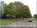
Baldock: Hommage ? Dixo
Following in one of our erstwhile leader's footsteps!
Image
Image: © Nigel Cox
Taken: 9 Oct 2011
0.04 miles
3
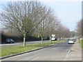
London Road, Baldock
Taken from TL246325 looking north, this shows London Road as it heads into the town of Baldock. While ordinary looking now, it was once a major Roman road and part of the medieval Great North Road, which ultimately became the A1, which now runs 600m west of this position.
Image: © Paul Dixon
Taken: 17 Mar 2005
0.13 miles
4
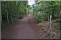
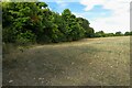
Path through Weston Hills Nature Reserve
Image: © Philip Jeffrey
Taken: 4 Sep 2022
0.16 miles
5
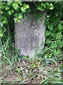
Old Milestone
Old milestone on London Road at Baldock, Hertfordshire. For overall view see http://www.geograph.org.uk/photo/3507223
Image: © Keith Evans
Taken: 16 May 2013
0.17 miles
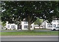
6
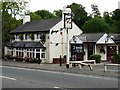
George IV
This public house, which sometimes has live music, is just on the edge of the town.
Image: © Mike W Hallett
Taken: 6 Jul 2009
0.18 miles
7
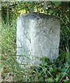
Old Milestone by the B197, London Road, Weston parish
Carved stone post by the B197, in parish of WESTON (NORTH HERTFORDSHIRE District), opposite "George IV" PH, on the verge, on West side of road. Stevenage stone, erected by the Stevenage & Biggleswade turnpike trust in the 19th century.
Inscription reads:-
36
(From London)
Carved benchmark and rivet on top.
Hertfordshire HER & St Albans UAD.
HHER Number: 5030 https://www.heritagegateway.org.uk/Gateway/Results_Single.aspx?uid=MHT5030&resourceID=1008
Milestone Society National ID: HE_LY36
Image: © MW Hallett
Taken: 16 Aug 2002
0.18 miles
8
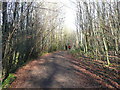
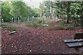
Path in Weston Hills Nature Reserve
This is the main path from the car park. Around the bend it drops down into a little valley, where it meets two public footpaths.
Image: © Humphrey Bolton
Taken: 18 Feb 2015
0.19 miles
9
Refreshing the woods
New tree planting at Weston Hills
Image: © Philip Jeffrey
Taken: 4 Sep 2022
0.20 miles
10
Woods at Weston Hills Nature Reserve
Image: © Philip Jeffrey
Taken: 4 Sep 2022
0.21 miles