IMAGES TAKEN NEAR TO
Rosemont Close, LETCHWORTH GARDEN CITY, SG6 4XR
Introduction
This page details the photographs taken nearby to Rosemont Close, SG6 4XR by members of the Geograph project.
The Geograph project started in 2005 with the aim of publishing, organising and preserving representative images for every square kilometre of Great Britain, Ireland and the Isle of Man.

There are currently over 7.5m images from over14,400 individuals and you can help contribute to the project by visiting https://www.geograph.org.uk
Image Map (Loading...)


Getting Data...Please wait
Leaflet Map data © OpenStreetMap
Images are licensed for reuse under creativecommons.org/licenses/by-sa/2.0
Notes
- Clicking on the map will re-center to the selected point.
- The higher the marker number, the further away the image location is from the centre of the postcode.
Image Listing (13 Images Found)
Images are licensed for reuse under creativecommons.org/licenses/by-sa/2.0
Image
Details
Distance
1
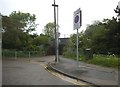
Foot tunnel under the railway, Letchworth
Image: © David Howard
Taken: 12 May 2018
0.08 miles
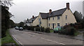
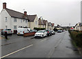
2
Houses on Broadwater Avenue, Letchworth
Image: © David Howard
Taken: 12 May 2018
0.09 miles
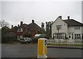
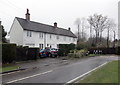
3
Spring Road at the junction of Station Way
Image: © David Howard
Taken: 12 May 2018
0.10 miles
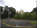
5
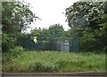
Electricity transformer on Burnell Rise, Letchworth
Image: © David Howard
Taken: 12 May 2018
0.20 miles
6
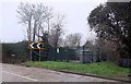
Electricity substation, Burnell Rise, Letchworth
Image: © habiloid
Taken: 16 Feb 2020
0.20 miles
9
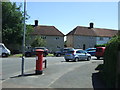
Abbotts Road, Letchworth
Showing position of Postbox No. SG6 170.
See Image] for postbox.
Image: © JThomas
Taken: 10 Jun 2017
0.23 miles
10
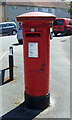
George V postbox on Bursland, Letchworth
Postbox No. SG6 170.
See Image] for context.
Image: © JThomas
Taken: 10 Jun 2017
0.23 miles