IMAGES TAKEN NEAR TO
Monklands, LETCHWORTH GARDEN CITY, SG6 4XN
Introduction
This page details the photographs taken nearby to Monklands, SG6 4XN by members of the Geograph project.
The Geograph project started in 2005 with the aim of publishing, organising and preserving representative images for every square kilometre of Great Britain, Ireland and the Isle of Man.

There are currently over 7.5m images from over14,400 individuals and you can help contribute to the project by visiting https://www.geograph.org.uk
Image Map
Images are licensed for reuse under creativecommons.org/licenses/by-sa/2.0
Notes
- Clicking on the map will re-center to the selected point.
- The higher the marker number, the further away the image location is from the centre of the postcode.
Image Listing (9 Images Found)
Images are licensed for reuse under creativecommons.org/licenses/by-sa/2.0
Image
Details
Distance
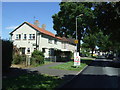
2
Highover Rd
Prefabs built after the war to provide quick, cheap and disposable housing. Still standing and well loved.
Image: © Robin Hall
Taken: 28 Jul 2005
0.07 miles
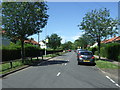
3
Bus stop on Bursland, Letchworth
Looking north.
Image: © JThomas
Taken: 10 Jun 2017
0.07 miles
5
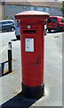
George V postbox on Bursland, Letchworth
Postbox No. SG6 170.
See Image] for context.
Image: © JThomas
Taken: 10 Jun 2017
0.12 miles
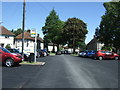
6
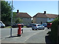
Abbotts Road, Letchworth
Showing position of Postbox No. SG6 170.
See Image] for postbox.
Image: © JThomas
Taken: 10 Jun 2017
0.12 miles
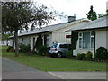
8
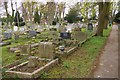
Icknield Way cemetery, Letchworth
This is the older, more tasteful end of the cemetery.
Image: © Ben Harris
Taken: 2 Apr 2011
0.18 miles
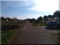
9
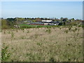
Fearnhill School, Letchworth
General view from the permissive footpath in the adjacent square.
Image: © Ian Paterson
Taken: 7 Apr 2011
0.18 miles