IMAGES TAKEN NEAR TO
Western Way, LETCHWORTH GARDEN CITY, SG6 4SR
Introduction
This page details the photographs taken nearby to Western Way, SG6 4SR by members of the Geograph project.
The Geograph project started in 2005 with the aim of publishing, organising and preserving representative images for every square kilometre of Great Britain, Ireland and the Isle of Man.

There are currently over 7.5m images from over14,400 individuals and you can help contribute to the project by visiting https://www.geograph.org.uk
Image Map (Loading...)


Getting Data...Please wait
Leaflet Map data © OpenStreetMap
Images are licensed for reuse under creativecommons.org/licenses/by-sa/2.0
Notes
- Clicking on the map will re-center to the selected point.
- The higher the marker number, the further away the image location is from the centre of the postcode.
Image Listing (8 Images Found)
Images are licensed for reuse under creativecommons.org/licenses/by-sa/2.0
Image
Details
Distance
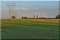
1
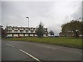
Northfields looking towards Western Way
Image: © David Howard
Taken: 12 May 2018
0.09 miles
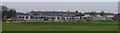
2
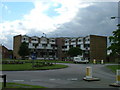
Western way flats.
In these parts this is what we call high rise. The philosophy of the Garden City is that all homes should have a garden. These flats are actually one two floor maisonette on top of another. Both have a patch of garden at the rear.
Image: © Robin Hall
Taken: 28 Jul 2005
0.11 miles
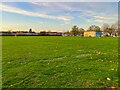
5
Grange Junior School
The grey portacabin at the right hand end of the building is the local scout hut.
Image: © Robin Hall
Taken: 14 Jan 2006
0.21 miles
6
Northfield Infants School.
In the same enclosure as Grange Junior School.
Image: © Robin Hall
Taken: 14 Jan 2006
0.21 miles
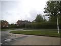
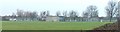
8
Grange Academy and its playing field
Image: © Philip Jeffrey
Taken: 30 Oct 2022
0.24 miles